Surf the coming swells
Southern Tasmanian Surf Forecast by Craig Brokensha (issued Wednesday April 19th)
Best Days: This afternoon, Thursday, Friday, Saturday for beginners, Sunday morning, Monday morning
Features of the Forecast (tl;dr)
- Moderate sized mix of W/SW swells peaking tomorrow with fresh N tending NW winds
- Easing surf Fri with N/NW tending W/NW winds
- Tiny surf Sat with N tending NW winds
- New W/SW groundswell Sun with W/NW tending SE winds
- Easing surf Mon with N winds
Recap
Tiny, teasing 1-1.5ft waves the last couple of days, but some new W/SW swell should start to build this afternoon as winds hold out of the W/NW.
This week and next (Apr 21 - 28)
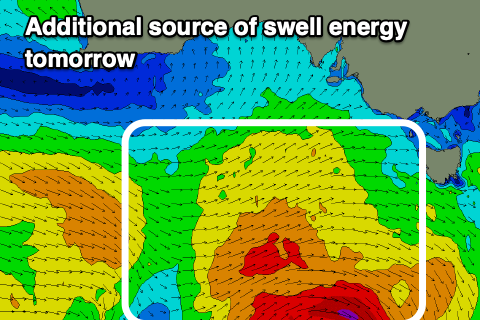
This afternoon's increase in W/SW swell energy should reach 2ft or so, with a peak in size due tomorrow. This will be mixed in with some additional W/SW swell from the storm linked to this afternoon's swell generating a fetch of strong W/SW winds in our western swell window last night.

Clifton looks to hold mostly 2ft, with the rare 3ft'er likely, easing back from 2ft on Friday. Conditions look good most of tomorrow with a fresh N tending NW breeze, then N/NW tending W/NW on Friday.
Saturday looks good for beginners with 1-1.5ft sets and N tending NW winds.
A new pulse of W/SW groundswell is due on Sunday, generated by a strengthening frontal system pushing in from the west on Saturday. EC has this system weaker than GFS, but regardless we should see 2ft sets across Clifton and with W/NW tending SE winds.
Weaker, frontal activity following this may generate some additional, tiny W/SW swell to 1-1.5ft but we'll review this on Friday.
It looks like we'll generally enter a little quiet window of surf, building later in the week, but check back here on Friday for more details.

