Building surf from Wednesday
Southern Tasmanian Surf Forecast by Craig Brokensha (issued Monday April 17th)
Best Days: Wednesday afternoon, Thursday, Friday morning
Features of the Forecast (tl;dr)
- Moderate sized mid-period W/SW swell building Wed PM, peaking Thu, easing Fri
- N/NW tending W/NW winds on Wed, gusty N/NW tending weaker W/NW winds Thu, N/NW tending W/SW winds Fri
Recap
Clean conditions but tiny surf on Saturday choppy and bottoming out yesterday. Today we've seen a small lift in swell thanks to a weak low forming south-west of us on the weekend. This will fade tomorrow.
This week and weekend (Apr 18 - 23)
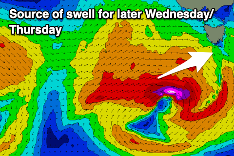
Today's swell is due to fade tomorrow (ideal for beginners) ahead of a healthy mid-latitude frontal system that's currently south-west of WA, dipping south-east and into our swell window during the afternoon and evening.
As it does so, a patchy fetch of strong to gale-force W/SW winds should be generated in our western swell window, while a secondary front will race in on the back of the storm, generating an additional fetch of strong to gale-force W/SW winds Wednesday afternoon and evening.

This will all be in our western swell window, with a moderate sized, mid-period W/SW swell due to build Wednesday afternoon, peaking Thursday.
Wednesday should see sets building to 2ft, with Thursday coming in at 2-3ft, (possibly a touch undersized early), then easing from 2ft on Friday.
Winds look generally favourable due to the persistent frontal energy, with NW tending W/NW winds on Wednesday, N/NW tending W/NW winds on Thursday and N/NW tending W/SW winds Friday.
As touched on last update, there's plenty more frontal activity due into next weekend and beyond, but all fairly north in track. This will result in W/SW swells with westerly winds. More on this Wednesday.

