Tricky winds with plenty of swell from the south
Southern Tasmanian Surf Forecast by Craig Brokensha (issued Monday November 14th)
Best Days: Selected spots Wednesday and Thursday, Friday morning, Saturday selected spots
Features of the Forecast (tl;dr)
- Moderate sized mid-period S swell building tomorrow with strong SW tending S/SW winds (lighter W at first light)
- Moderate sized S/SE swell for Wed, easing slowly Thu with strong S/SW winds Wed and SW winds Thu (W for a period through the early-mid AM)
- E/NE tending S/SW winds Fri with easing S/SE swell
- New SW swell for later Thu, peaking Fri, with a reinforcing swell Sat AM, easing
- Fresh N/NE tending stronger NE winds
Recap
Poor conditions with an onshore wind Saturday, cleaner Sunday but tiny and easing from 1ft.
Today a new swell has started to build with clean conditions and sets to 1-2ft, now onshore and with more size.
This week and weekend (Nov 15 - 20)
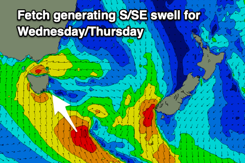
Today's strengthening S/SW winds are associated with a deepening low being dragged up from the south-west across the state. This low will generate a fetch of strong to sub-gale-force S'ly winds up and into us this evening and tomorrow, with a great intensification in our south-southeastern swell window, generating some better, prolonged S/SE swell energy.
This will see a rapid jump in mid-period S'ly swell through tomorrow, reaching 3-4ft through the afternoon across Clifton but with strong SW tending S winds. At first light we're likely to see lighter W winds, but it won't be worth chasing too hard.
 The swell will still be solid and in the 4ft range out of the S/SE on Wednesday but with strong S/SW winds owing to the slow movement of the low east. This will prolong S/SE energy into Thursday with sets still due to come in at 3ft with cleaner conditions likely in the morning under a W'ly breeze, shifting SW late morning and S/SW into the afternoon.
Friday looks clean again in the morning but with smaller, fading 1-2ft sets from the S/SE.
There should be some new SW swell in the water Thursday afternoon and Friday, generated by a low firing up to the south-west of Western Australia.
Pre-frontal NW gales should produce 2ft sets, with post-frontal SW winds maintaining less consistent 2ft sets on Saturday morning before easing during the day.
Winds will swing back to the N/NE on Saturday and then strengthen from the NE into the afternoon so go the morning surf.
Looking longer term and a strengthening frontal progression moving in from the west should generate some decent W/SW swell energy for early next week under westerly winds, but we'll review this Wednesday.


Comments
Good direction.
Indeed.