Fun weekend of waves, mixed winds and swells next week
Southern Tasmanian Surf Forecast by Craig Brokensha (issued Friday August 26th)
Best Days: Satuday morning, Sunday morning, Monday afternoon, Wednesday, Thursday morning
Features of the Forecast (tl;dr)
- Small, inconsistent W/SW swell tomorrow, easing later and further Sun
- N/NW tending SE winds Sat, fresh N/NE tending NE winds Sun
- Inconsistent, long-period W/SW groundswell for Mon PM with fresh N/NE winds, easing ahead of a late, weak SW change
- Easing groundswell Tue with fresh SW tending S winds
- Moderate sized, mid-period SW swell building later Wed, peaking Thu with NW winds Wed and NW tending NE winds Thu
- Possible bigger swells next weekend but with SW winds
Recap
Bumpy conditions yesterday with a weak onshore breeze and 2ft of swell, much cleaner today and fun as the swell steadies in the 2ft range.
This weekend and next week (Aug 27 – Sep 2)
We've got fun waves due across the South Arm on the weekend with one final pulse of reinforcing W/SW energy due into this afternoon and tomorrow morning, easing under favourable winds.
Tomorrow morning should hold 2ft with a N/NW offshore, though SE sea breezes are due into the afternoon, with Sunday seeing easing 1-2ft sets with less consistency and fresh N/NE tending gusty NE winds.
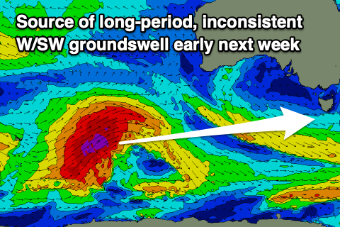
 A low point in swell is due on Monday morning ahead of our inconsistent, long-period W/SW groundswell into the afternoon.
This swell is being generated by a strong low in our far swell window, east of the Heard Island region. A great fetch of gale to severe-gale W/SW winds have and are still being generated with the low starting to move out of our swell window as it projects north-east towards Western Australia.
The swell should start showing Monday afternoon and reach an inconsistent 2ft across Clifton by late along with persistent N/NE winds ahead of an evening SW change.
This change looks weak, but it'll strength into the evening with Tuesday seeing poor SW tending S'ly winds as the groundswell eases.
 Wednesday should become cleaner again with smaller 1-2ft leftovers, but into the afternoon some new mid-period SW swell is due to arrive, followed by reinforcing pulses into the end of the week.
The source of these swells will be polar frontal activity moving in from south-west of Western Australia during the weekend and early next week, with each swell looking to come in around 2-3ft across Clifton. There's the possibility for some larger surf later Friday and next weekend, but the frontal system linked to this will cross us, bringing onshore SW winds.
More on this and the windows of cleaner conditions Monday. Have a great weekend!

