Plenty of fun surf from Friday
Southern Tasmanian Surf Forecast by Craig Brokensha (issued Wednesday August 24th)
Best Days: Friday, Saturday, Sunday, Monday afternoon, Tuesday morning for the keen
Features of the Forecast (tl;dr)
- Reinforcing W/SW swell for Thu and Fri
- Moderate SW winds tomorrow
- New mid-period SW swell Fri PM and Sat with N/NE tending E/NE winds
- N/NW tending weak S/SE winds Fri, moderate N tending NE winds Sat
- Easing surf Sun with fresher N/NE tending NE winds
- Inconsistent W/SW groundswell for Mon PM with N tending NE winds, easing Tue with weak SW winds, strengthening through the day
Recap
A solid kick in size yesterday with a mix of new W/SW groundswell and mid-period energy with 3ft to occasionally 4ft sets. The size has eased back a little to 2-3ft this morning along with great conditions.
This week and weekend (Aug 23 - 28)
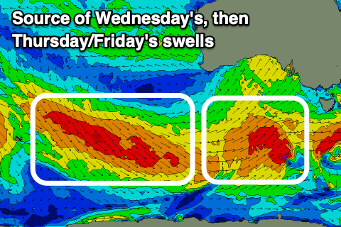
We've seen two pulses of seperate W/SW swell energy impacting the arm and we've got two more due through the end of the week and Saturday morning, generated by an elongated fetch of strong to gale-force W/NW tending W winds swinging in from east of the Heard Island region.
Fun 2-3ft sets should continue across Clifton tomorrow, more so 2ft to occasionally 3ft Friday, then easing back from a similar size Saturday morning.
 Winds will unfortunately be onshore tomorrow and moderate from the SW in the wake of one of the swell generating fronts clipping us.
Friday looks great with a N/NW tending weak S/SE breeze and then N tending NE wind on Saturday.
Come Sunday the surf will be smaller and easing from 1-2ft with fresher N/NE tending NE winds.
A low point in swell is expected on Monday morning ahead of a new, inconsistent W/SW groundswell later in the afternoon, easing Tuesday.
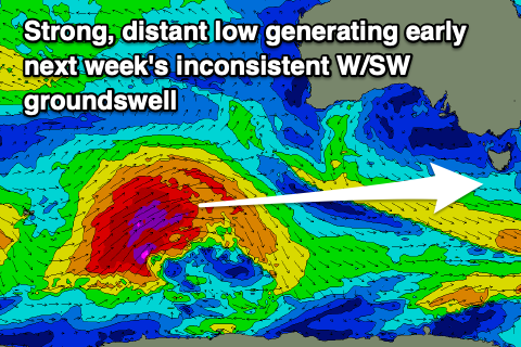
The source of this swell will be a strong but distant polar low generating a fetch of severe-gale to storm-force W/SW winds through our swell window before tracking north-east and towards Western Australia, north of our swell window.
 Due to this north-east track we'll see a small, infrequent swell arriving Monday afternoon and reaching 2ft on the sets, easing from a similar size Tuesday.
Conditions look favourable for select locations Monday with a N tending NE breeze, while a shallow change is due Tuesday morning, stronger S/SW into the afternoon.
Longer term there's some fun W/SW swell energy due into the middle to end of next week, possibly larger into the weekend but more on this Friday.

