Good westerly swells inbound
Southern Tasmanian Surf Forecast by Craig Brokensha (issued Monday August 22nd)
Best Days: Tomorrow morning, Wednesday, Friday morning, Saturday morning, Sunday morning
Features of the Forecast (tl;dr)
- Peak in moderate sized W/SW swell energy tomorrow with N/NW tending strong W/SW winds late AM, followed by a reinforcing pulse Wed with N/NW tending W/NW winds
- Slight drop in size Thu with W/SW-SW winds
- Reinforcing W/SW swell for Thu and Fri
- N tending SE winds Fri
- New mid-period SW swell Fri PM and Sat with N/NE tending E/NE winds
- Easing surf Sun with strengthening N/NE tending NE winds
- Inconsistent W/SW groundswell for Mon PM with W/NW winds
Recap
Poor conditions with an onshore change and choppy 1-2ft waves Saturday, much better yesterday with a reinforcing mid-period SW swell and clean 2ft sets. The swell eased through the day and we've fallen in between swells this morning with tiny clean conditions.
This week and weekend (Aug 23 - 28)
From later today but more so tomorrow we should see fun waves developing across the South Arm as the first in a series of W/SW swells arrives thanks to an active Southern Ocean storm track.
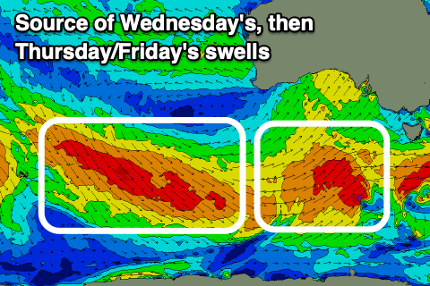
This first swell was generated by a healthy polar low firing up south-west and south of the country, generating a fetch of strong to gale-force W/SW winds. Satellite observations picked up a small, tight fetch of storm-force W/SW winds around the core of the low, and we can expect fun, inconsistent 2-3ft sets with a morning N/NW offshore, shifting strong W/SW later morning with a change.
 This change will be linked to a secondary polar front racing in from the west, generating a reinforcing W/SW swell for Wednesday to a similar 2-3ft along with favourable N/NW tending W/NW winds.
From Thursday reinforcing pulses of mid-period W/SW tending swell are due from a great fetch of strong to gale-force W/NW winds swinging in from east of the Heard Island region.
This should maintain inconsistent 2-3ft sets across Clifton on Thursday but with less favourable and gusty W/SW-SW winds, easing a touch Friday as offshore N'ly winds kick in again.
Into Friday afternoon and Saturday morning, another reinforcing pulse of mid-period SW swell is due, but the frontal activity generating this doesn't look overly strong.
As a result 2ft+ sets are due to continue, easing into Sunday. Conditions will be clean again as winds tend more N/NE, though sea breezes are due into Saturday afternoon, less so Sunday with stronger NE breezes.
Longer term, a very strong polar low firing up south of the Heard Island region mid-late week looks to generate an inconsistent W/SW groundswell for early next week but we'll have a closer look at this Wednesday. Size wise it looks to be around 2ft but more on this next update.

