Increasing surf activity next week
Southern Tasmanian Surf Forecast by Craig Brokensha (issued Friday August 19th)
Best Days: Sunday morning, Tuesday, Wednesday, Friday
Features of the Forecast (tl;dr)
- Strong S/SW winds tomorrow, easing later
- Small mid-period SW swell Sun AM, easing through the day with N/NW tending NW winds
- SW tending W/SW winds Mon with a late increase in new W/SW swell
- Peak in in W/SW swell energy Tue with NW tending W/NW winds, followed by a reinforcing pulse Wed with N/NW winds
- Slight drop in size Thu with SW tending SE winds
- Good SW groundswell Fri with N winds
Recap
Tiny surf both yesterday and today, with a tiny W/SW swell for today not really showing that well.
This weekend and next week (Aug 20 - 26)
Tomorrow will be a write-off with a strong S/SW change as a cold front pushes across us, kicking up a small localised windswell mixed in with some new SW groundswell. Choppy 2ft waves are due but with no quality.
 Sunday should clean up rapidly with a gusty N/NW tending NW breeze and new, mid-period SW swell.
This swell will be generated today by a polar fetch of strong W/SW winds, weaker than forecast on Wednesday. With this we're only due to see 1-2ft sets in the morning, fading into the afternoon.
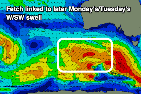
We then look ahead to the pulses of swell due from later Monday but more so Tuesday next week across the region.
An initial polar low should generate a patchy fetch of strong to gale-force W/SW winds while pushing east today and tomorrow, weakening south-west of us Sunday but still generating a W/SW fetch.
 This should produce a fun W/SW swell for later Monday but to 2ft, though peaking Tuesday to 2-3ft and with NW tending W/NW winds. Winds on Monday look a little dicey with an early SW change, easing and swinging back to the W/SW.
Some reinforcing W/SW swell is due Wednesday from trailing activity, maintaining 2-3ft sets with persistent N/NW winds.
Longer term, additional polar fronts strengthening south-west of us look to generate some more favourable and better sized SW swell into the end of the week and next weekend more to 3ft+ but we'll have a closer look at this Monday. Have a great weekend!

