Increasing activity into next week
Southern Tasmanian Surf Forecast by Craig Brokensha (issued Wednesday August 17th)
Best Days: Friday afternoon, Sunday, Tuesday
Features of the Forecast (tl;dr)
- Tiny W/SW swell for Fri PM with NW tending N/NW winds
- Better SW groundswell Sat but with strong SW winds
- Reinforcing SW swell Sun with N/NW winds
- Inconsistent W/SW groundswell for Tue with W/NW winds
Recap
Average conditions and average swell yesterday morning, building into the afternoon with strengthening onshore winds. Today is cleaner but easing with fading, close spaced 1-2ft sets. That being the nature of the locally generated swell.
This week and weekend (Aug 18 - 21)
With the easing windswell across the South Arm today, there'll be nothing left in the tank tomorrow so we look to our small, W/SW swell due Friday with an additional SW pulse for the weekend now on the cards.
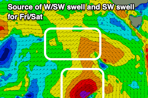
 The source of these swells will be a low that's currently south of the Bight, generating a patchy fetch of strong to gale-force W/SW winds while dipping south-east. This will generate the tiny W/SW swell for Friday, peaking into the afternoon to 1-1.5ft and with NW tending N/NW winds.
At the base of the low, on the polar shelf a tiny fetch of gale to severe-gale SW winds are forecast to be generated in our south-western swell window with the swell coming in Saturday to 2ft.
Unfortunately the backside of the low will bring strong SW winds on Saturday, cleaner Sunday as it quickly clears and winds shift back to the N/NW. Swell wise, a reinforcing pulse of mid-period SW swell is due from another polar fetch of strong to near gale-force W/SW winds Friday, and this should maintain small 1-2ft sets.
 We then look at the Southern Ocean activity due to develop through the weekend and next week to our west and south-west.
An initial strong but weakening and broadening polar low looks to generate an inconsistent W/SW groundswell for Tuesday, coming in at an inconsistent 2-3ft across Clifton along with W/NW winds.
Follow up activity behind this low is still up for grabs as the models try and resolve each frontal system. In short there's plenty more swell and possibly with more size due through the rest of next week, but we'll have a closer look at this come Friday.

