Low goes west, low goes east
Southern Tasmanian Surf Forecast by Craig Brokensha (issued Friday August 12th)
Best Days: Saturday morning, Wednesday
Features of the Forecast (tl;dr)
- New S/SE swell tomorrow with NW tending SW then S/SW winds while increasing through the PM
- Rapid jump in junky SE windswell Sun with strong SE winds, easing a touch and tending E/SE
- Easing SE windswell Mon with E/SE tending SE winds
- Building S/SE swell Tue with strengthening S/SW winds
- Easing S/SE swell Wed with N winds
Recap
Wednesday's swell backed off into yesterday, with tiny waves seen across the Arm, continuing into today.
This weekend and next week (Aug 13 - 19)
Tricky.
In a word that's the outlook for the coming few days as a broad and strong mid-latitude meanders this way and that, into and out of our swell window bringing varying swell pulses and mixed winds.
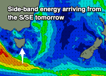
 Firstly tomorrow, some small side-band S/SE energy should fill in across Clifton, generated by a fetch of strong SE winds south of us today.
The size looks a little smaller than forecast on Monday with consistent 2ft waves mixed in with the odd bigger one at times.
Conditions look clean with a morning NW breeze, shifting SW through the morning and then increasing into the afternoon while tending more S/SW as the low pushes back west and under us.
As the low moves back west tomorrow an embedded front will see an intensification of gale-force SE winds moving quickly through our swell window, kicking up a spike in localised SE swell on Sunday to 3ft along with strong SE breezes, easing and tending more E/SE through the day.
Unfortunately with this combo of wind and swell there'll be nowhere to really recommend.
The low now looks to linger across us into Monday which will maintain poor E/SE tending SE winds into Monday but with smaller surf as the SE windswell eases. Expect smaller, junky 2ft waves.
Tuesday is still looking poor as the low starts to shift back to the east, bringing strengthening S/SW winds from the backside of the low and an increase in weak S/SE swell building back to 2-3ft.
This S/SE swell will drop quickly into Wednesday as winds go offshore from the N'th. 2ft sets are expected, fading through the day.
So all in all this swell looks to go to waste with tomorrow morning and Wednesday morning being the best chances to surf
Longer term there's a bit more swell potential from next weekend and into next week. More on this Monday. Have a great weekend!

