Building swells from the south-eastern quadrant from the weekend
Southern Tasmanian Surf Forecast by Craig Brokensha (issued Wednesday August 10th)
Best Days: Saturday, Monday
Features of the Forecast (tl;dr)
- Fading W/SW swell with fresh N/NE winds tomorrow
- Building S swell Sat with variable winds, shifting onshore later
- Building moderate sized SE windswell Sun with strong SE winds, easing Mon with possible N winds
- Easing surf Tue with gusty SW winds
Recap
Tiny surf yesterday to 1ft, while today there's reports of a small W/SW swell to 1-2ft, the source being a distant polar low to the east of Heard Island last week. I mentioned this swell last week but forget to rehash it on Monday.
This week and weekend (Aug 11 - 14)
Today's swell will fade tomorrow leaving tiny waves across Clifton and with fresh N/NE winds, near flat Friday with variable tending S/SE winds.
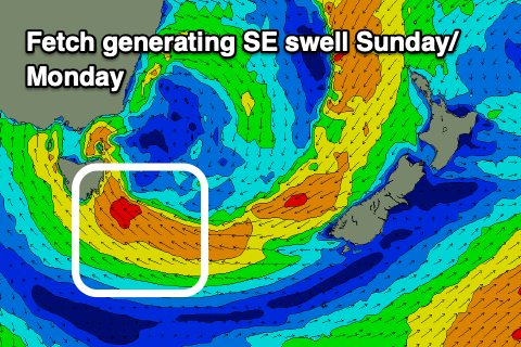
We then look at the deepening low and mix of S and SE swell due over the weekend.
This low is now looking stronger and will linger more south in latitude, bringing more size to the South Arm.
We should see the first signs of S'ly swell building Saturday as the southern flank of the low moves into our swell window on Friday.
Building surf to 2-3ft is due through the day with light winds, strengthening later in the day ahead of poor, strong SE winds on Sunday as the low moves further east and deepens.
 This will kick up some chunky SE windswell, building to 4ft into the afternoon with Monday seeing similar sized waves.
The local winds on Monday revolve around the position of the low. If it shifts south-west N'ly winds are expected along with easing size, but if it remains in our region winds will remain onshore with a more prolonged swell event.
On Tuesday we're likely to come under the influence of the tail of the low, bringing gusty SW winds and easing E/SE surf but we'll have a closer look at this on Friday.
At the same time as the SE swell energy, some small S/SW groundswell is expected to be in the mix but this will be hard to decipher and to a lesser size.
Check back Friday for an update on how the weekend and early next week are shaping up.

