Rare E/SE groundswell
Southern Tasmanian Surf Forecast by Craig Brokensha (issued Friday July 8th)
Best Days: Sunday
Features of the Forecast (tl;dr)
- Building S/SE windswell tomorrow with strong S/SE winds
- Inconsistent E/SE groundswell Sun, easing into the PM with light N-N/NW tending fresh NE winds
- Fading E/SE groundswell Mon with strong N/NE winds
Recap
Clean but easing surf through yesterday, poor today with a change in the weather and onshore winds.
This weekend and next week (Jul 9 - 15)
The change in weather and wind today is linked to a surface trough moving across us, and it's generating a fetch of weak S/SE winds in our southern swell window.
This will kick up a weak SE swell through tomorrow, building from 2ft to 2-3ft during the afternoon across Clifton but with strong S/SE winds.
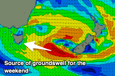
 Of greater importance is the E/SE groundswell due on Sunday, generated by a better fetch of SE gales off the tip of New Zealand's South Island this evening and tomorrow morning.
The swell won't be ideally aimed for Clifton but be favourable for spots down the Arm. Clifton should see 2ft sets at is peaks through the morning and with a light N-N/NW tending fresh NE breeze.
We may still see rare 1-2ft sets early Monday (likely 1-1.5ft) across Clifton but the swell will be on the way out with stronger N/NE winds.
Looking at the rest of next week there's nothing major on the cards with the storm track being too far north for us. More on this Monday. Have a great weekend!

