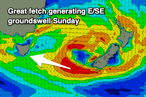
Our attention swings to the south-east
Southern Tasmanian Surf Forecast by Craig Brokensha (issued Wednesday July 6th)
Best Days: Tomorrow morning, Sunday selected spots
Features of the Forecast (tl;dr)
- Small, easing S/SW swell tomorrow with N/NW winds
- Onshore S/SW tending S/SE winds with a building S/SE windswell Fri
- Peak in S/SE windswell Sat AM, easing with fresh S/SE winds
- Good E/SE groundswell Sun with freshening N/NE winds
- Fading E/SE groundswell Mon with strong N/NE winds.
Recap
Fun 2ft surf yesterday while a reinforcing pulse of S/SW energy has come in at a good 2-3ft this morning, though has since eased back to 2ft.
This week and weekend (Jul 7 - 10)
Today's swell will continue to ease overnight but seeing the size today, tomorrow should still see 1-2ft sets, fading through the day. A N/NW tending variable wind will keep conditions clean and then Friday will be poor as trough moves through bringing strong SW tending S/SE winds.
 Now, this trough is expected to deepen into a low with a fetch of strong S/SE winds projected up and into us Friday afternoon, easing Saturday.
This will produce a weak S/SE swell for Saturday to 2-3ft or so but with fresh, lingering S/SE winds.
As the swell eases on Sunday, some new E/SE groundswell is due across selected breaks, generated by a much more significant fetch of SE gales off the southern tip of New Zealand's South Island Friday night and Saturday.
This will be large on the East Coast but we should see 2ft sets across Clifton from this source, much larger down the arm.
Winds should improve and swing around to the N/NE on Sunday but this will favour selected spots over others.
Into next week the E/SE groundswell will ease and there's a few tiny W/SW swells on the cards but nothing of any major size. More on this Friday.

