Good run of swell and winds from Friday
Southern Tasmanian Surf Forecast by Craig Brokensha (issued Wednesday June 29th)
Best Days: Friday, Saturday, Sunday, Monday, Tuesday, Wednesday morning
Features of the Forecast (tl;dr)
- Building mid-period SW swell tomorrow, peaking Fri
- Strong but easing S/SW tending W/SW-SW winds tomorrow
- Strong SW groundswell also in the mix Fri with NW tending variable winds
- Easing mix of swells Sat with NW tending W/NW winds
- Reinforcing SW swell Sun with NW tending variable winds
- Strong SW groundswell Mon, easing into the PM wih NW tending variable winds
Recap
Tiny waves yesterday, ideal for beginners while a small pulse of mid-period W/SW swell has been seen today with fun 1-1.5ft sets.
This week and weekend (Jun 30 – Jul 3)
Now that the small stuff is out of the way, we've got some better and larger swell on the way over the coming days and into early next week.
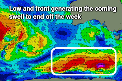
 These swells are and will continue to be generated by some great polar frontal activity that's developing south-west of us, then tracking east.
An initial strong polar low has generated a great fetch of severe-gale to storm-force W'ly winds and will be followed by a fetch of strong SW winds pushing up and under us tomorrow.
We should see a mix of mid-period SW swell building tomorrow ahead of the groundswell late in the day, peaking Friday.
The morning looks to be 1-2ft in the morning, but kicking to 2-3ft late in the day with 3ft surf on Friday.
There might be the rare bigger one on Friday but expect mostly head-high waves.
Winds will be poor tomorrow as the front pushes up and across us, with pre-dawn strong S/SW winds due to ease and shift SW-W/SW for a period in the morning, then SW into the afternoon.
Friday looks much better with NW tending variable winds.
The swell will start to ease on Saturday back from the 2ft+ range and conditions look to remain clean with NW tending W/NW breezes.
 Some reinforcing SW swell is expected on Sunday, maintaining 2ft sets across Clifton, generated by a pre-frontal fetch of W/NW winds, but come Monday a stronger long-period SW groundswell is on the cards. This will be generated by a fast tracking but strong low, producing a fetch of severe-gale to storm-force W'ly winds on Friday evening and Saturday.
A good spike in size back up to 3-4ft is due and with N/NW tending variable winds both Sunday and Monday.
The swell will be short-lived due to the fast track of the low with easing size due through Tuesday from 2ft, smaller Wednesday but with clean conditions.
From here onwards mid-latitude storm activity looks to result in a run of smaller surf, but more on this Friday.

