Building surf from Wednesday
Southern Tasmanian Surf Forecast by Craig Brokensha (issued Friday June 24th)
Best Days: Tomorrow and Wednesday beginners, Friday, Saturday, Sunday, Monday
Features of the Forecast (tl;dr)
- Tiny tomorrow with N/NW tending variable winds
- Small W/SW swell Wed with N/NW winds
- Building mid-period SW swell Thu, peaking Fri
- Strong but easing SW winds Thu
- Strong SW groundswell also in the mix Fri with W/NW tending W/SW winds
- Easing mix of swells Sat with W/NW tending variable winds
- Reinforcing SW swells Sun and Mon
Recap
A fun new W/SW swell on Saturday with 2ft sets and great conditions, easing a touch Sunday and down more to 1-1.5ft. Today the swell is hanging in that tiny 1.5ft range with peaky, clean conditions.
This week and weekend (Jun 28 – Jul 3)
 The surf will remain around the tiny 1-1.5ft range tomorrow morning as one final pulse of mid-period SW swell fills in from weak polar frontal activity on the weekend. It should be nice for beginners with moderate N/NW winds, easing into the afternoon and becoming variable.
From Wednesday onwards we should see building levels of SW swell as a progression of polar fronts starts to fire up south-west of us.
There should be a small, inconsistent mid-period W/SW swell to 1-2ft on Wednesday (with N/NW winds) but Thursday afternoon onwards is much more reliable regarding increasing swell activity.
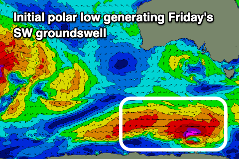
An initial strong polar low is due to generate a SW groundswell for late Thursday and more so Friday, coming in at 3ft, but additional levels of mid-period swell will be in the mix from Thursday as a trailing polar front pushes up and into us.
 This will bring strong but easing SW winds on Thursday and building sets to 2-3ft into the afternoon, 3ft on Friday mixed in with the groundswell. Due to the seperate swells we may see the odd bigger set at times on Friday and winds should tip back to the W/NW, shifting W/SW for a period into the afternoon.
Easing 2-3ft sets are due on Saturday with a light W/NW tending variable breeze, while some reinforcing SW swell energy should be seen Sunday ahead of a larger groundswell Monday. The models are still moving a little regarding the strength of these swell producers so check back here on Wednesday for a clearer idea.

