Fun options from late Friday
Southern Tasmanian Surf Forecast by Craig Brokensha (issued Wednesday June 22nd)
Best Days: Late Friday, Saturday, Monday morning
Features of the Forecast (tl;dr)
- Building mid-period W/SW swell Fri PM, holding Sat, easing Sun
- N tending W/NW winds Fri, fresh but easing N/NW winds Sat and strong W/SW winds Sun
- Easing SW windswell Mon with N/NW winds
Recap
Tiny waves yesterday with a little hint of E/SE swell across magnets, effectively flat today.
This week and weekend (Jun 23 - 26)
Tiny to flat surf will continue tomorrow and Friday morning ahead of some new, building W/SW swell energy later in the day, holding through Saturday.
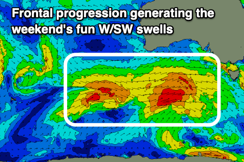
 The source of this swell will be a progression of mid-latitude fronts pushing in from the west over the coming days, generating fetches of strong to near gale-force W/SW winds in our western swell window.
It’ll be mostly mid-period energy and west in nature with sets to 2ft+ due later Friday, coming in at 2ft to occasionally 3ft on Saturday, easing from 2ft on Sunday.
N tending W/NW winds will faovur protected locations Friday afternoon as the swell builds, with great, persistent N/NW winds blowing all day Saturday (fresh in the morning).
A strong W/SW change is due around dawn on Sunday, creating poor conditions and kicking up a weak 1-2ft of windswell which looks to ease Monday as winds tip back to the N/NW.
Longer term we may see some new mid-period SW swell building through the middle of next week, but with poor winds. More on this in Friday’s update.

