Extended run of large, stormy surf
Southern Tasmanian Surf Forecast by Craig Brokensha (issued Wednesday June 8th)
Best Days: Protected spots every day, Tuesday exposed spots
Features of the Forecast (tl;dr)
- Moderate sized + S/SW swell tomorrow with strong W/SW-SW winds
- Larger S/SW swell building Fri with strong W/SW-SW winds
- Significant increase in S'ly groundswell later Sat, holding most of Sun with strong W/NW winds, shifting SW mid-late PM Sat and strong SW winds Sun (possibly W/SW early)
- Easing S/SE swell Mon with fresh W/SW winds, smaller Tue with NW tending W winds
Recap
Average, building surf through yesterday, larger today as the first in a series of strengthening polar fronts and push up across us.
This week and next week (Jun 9 - 17)
Today is just a taste of what's to come over the coming week, with one of the most prolonged run of large S/SW swell I've forecasted set to unfold.
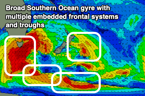
 The reason for all the cold weather, wind and surf is a large Southern Ocean gyre that's developed under the influence of a very slow moving and pronounced node of the Long Wave trough.
The gyre pans a region south-west of us to the east of New Zealand and we'll see multiple polar fronts spinning around it, spawning directly south of us, in our southern swell window.
With each frontal system being stronger than the previous and also acting on an energised sea state created before it, we'll see a large, prolonged run of windy S/SW swell.
So looking at the evolution and a strong polar front pushing up and across us this evening should generate a new pulse of mid-period S/SW swell for tomorrow to 4-5ft across Clifton.
Into tomorrow evening an even stronger cold front will project gales up and into us, producing an additional increase in S'ly swell to the 6ft range into Friday afternoon.
Come the weekend we'll see the strongest and most elongated of the polar fronts developing south of us, projecting gale to severe-gale S/SW winds up through our southern swell window.
This will generate a large, significant S/SW groundswell building to 8ft later Saturday, holding that 8ft range Sunday morning. Add into the mix snow to near sea level and we're talking quite a significant system.
The gyre as a whole will start moving east on Sunday and this will see winds start to relax on Monday with easing large S'ly swells from the 6ft range, still 3ft and more out of the S/SE on Tuesday.
Now, coming back to the local winds and strong W/SW-SW breezes are due tomorrow and Friday with the weekend seeing strong W/NW winds most of Saturday, shifting SW mid-late afternoon, then SW all day Sunday (possibly W/SW early).
Monday looks to see fresh but lingering W/SW breezes, cleaner across Clifton Tuesday with a NW tending W/NW breeze.
Longer term we may see a final good pulse of SE groundswell later in the week off the backside of the gyre, but more on this Friday.


Comments
WOW what a system! Any other state with a swell event like this the comments would be lit up. Can't wait to see some footage.