Tiny weekend, building slowly next week
Southern Tasmania Surf Forecast by Craig Brokensha (issued Friday April 29th)
Best Days: Beginners Sunday, later Monday, Tuesday
Features of the Forecast (tl;dr)
- Tiny W swell Sun with N/NW winds
- Mid-period W/SW swell and inconsistent W/SW groundswell building Mon PM with N winds, easing Tue with strengthening N/NE winds
- Moderate sized W/SW groundswell building Wed PM with NW tending SW winds, easing Thu with W/SW tending SW winds
Recap
Ideal conditions for beginners with light winds and clean conditions, tiny and micro today.
This weekend and next week (Apr 30 - May 6)
*also: Tim Bonython's Australian Surf Movie Festival is coming up real soon, with incredible new 8K footage of Nazaré, Jaws, Mavericks, Teahupo’o and more, that simply HAS to be seen on the big screen. Get your tickets to the Hobart show (Village Cinema) on Sat 7th May here: https://swllnt.com/3v2MlNc
As touched on the last few updates we’ve got a tiny run of swell for the coming period thanks to the storm track being too far north and out of our swell window.
In saying this we should see a weak front moving under us tomorrow, bringing a tiny pulse of W’ly swell Sunday to 1ft or so along with persistent N/NW winds, ideal for beginners.
A slightly stronger and broader front moving under us Sunday evening will generate a better pulse of mid-period W/SW swell to 1-2ft later in the day Monday.
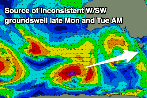
 Also in the mix should be an even stronger, less consistent W/SW groundswell for the afternoon, produced by a distant polar low that’s south-southwest of Western Australia. This should pulse to 2ft+ and with a favourable N’ly breeze.
Easing inconsistent 2ft sets are due on Tuesday but with strengthening N/NE winds.
Into later Wednesday, a moderate sized W’ly groundswell is on the cards, generated by a strong, very distant polar low firing up from west of the Heard Island region, projecting a weakening fetch of severe-gale to storm-force W/SW winds. It won’t be ideally aimed for us but the longevity and strength should produce 2-3ft sets late Wednesday and Thursday morning.
Unfortunately winds will swing onshore from the SW Wednesday afternoon in the wake of the swell generating front passing across us with W/SW tending SW winds on Thursday.
Longer term we may see a low forming just east of the state later next week/weekend bringing poor conditions and weak S/SE swells, but more on this Monday. Have a great weekend!

