Great weekend, plenty more surf next week
Southern Tasmanian Surf Forecast by Craig Brokensha (issued Friday April 15th)
Best Days: Tomorrow, Sunday, Tuesday morning, Wednesday, Thursday and Friday
Features of the Forecast (tl;dr)
- Moderate sized SW groundswell tomorrow AM, with a stronger S/SW pulse for later in the day, easing Sun
- Variable tending N/NE-NE winds tomorrow, variable again late
- Strengthening N tending N/NE winds Sun
- Smaller Mon AM with strong S/SW tending fresh S/SE winds
- Inconsistent W/SW groundswell for Mon PM, easing Tue with N tending S winds
- Larger surf later next week with increasing winds from the western quadrant
Recap
Our great run of surf continued into yesterday with a slight drop in size back to 2-3ft, kicking again into the afternoon with a reinforcing pulse of SW groundswell. This has kept 2-3ft waves hitting the coast this morning and is now slowly easing.
This weekend and next week (16 - 22)
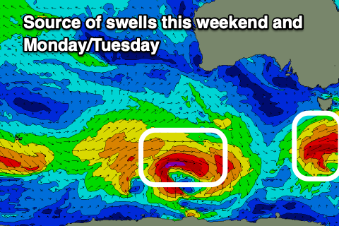
We've got one more final pulse of clean, strong swell due over the weekend, arriving from a strong low that's currently pushing towards and under us.
A great fetch of strong to gale-force W/SW winds have been generated, with the tail of the low due to generate a fetch of gale to severe-gale SW winds in our southern swell window.
We'll see a moderate size SW groundswell for tomorrow, with some S/SW component later in the day, easing Sunday.
 Size wise Clifton should come in at 3ft again tomorrow morning with 3ft+ sets later in the day along with variable tending NE-N/NE winds, freshening through the day to the east, going variable again around Clifton.
Strengthening N tending N/NE winds are due on Sunday as the S/SW swell eases back from 2ft to occasionally 3ft.
Looking at Monday and unfortunately a trough will bring a S/SW change just before dawn but the swell will be at a low point. Some inconsistent W/SW groundswell is due into the afternoon, generated by a fractured polar low that's currently south-west of Western Australia but only to 2ft+, easing Tuesday from 2ft with N'ly winds ahead of S'ly sea breezes.
Following this a stronger and multi-threaded polar frontal progression will move in from the west next week, generating some larger surf into the middle to end of the week but with windier conditions. We'll have a closer look at this Monday though. Have a great weekend!


Comments
Can see that it has to wrap a little bit but 3ft at Clifton. Big shippies.