Great run of surf until Monday
Southern Tasmanian Surf Forecast by Craig Brokensha (issued Wednesday April 13th)
Best Days: Tomorrow, Friday, Saturday, Sunday
Features of the Forecast (tl;dr)
- Slight drop in swell Thu AM, building into the PM with a reinforcing SW groundswell. N/NW tending variable winds
- Easing surf Fri with light N/NW tending W/NW winds ahead of a late W/SW change
- New SW groundswell filling in Sat with variable tending N/NE winds, strengthening into the PM
- Easing surf Sun with fresh N/NE winds, easing
Recap
Smaller surf yesterday, easing back to a clean 1-2ft, but our strong pulse of S/SW groundswell for today has come in nicely with 3ft sets and light offshore winds across Clifton.
This week and next week (14 - 22)
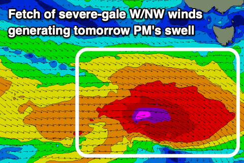
 The strong polar low linked to today's swell has been followed up by a significant fetch of severe-gale W/NW winds pushing through our swell window today.
This will generate a strong reinforcing SW groundswell for tomorrow afternoon as today's S/SW energy eases.
Tomorrow morning we'll fall between swells with sets to 2-3ft, with the new swell pulsing to 3ft+ into the afternoon.
Winds look great with a light N/NW tending variable breeze, remaining variable into the afternoon.
The swell will ease Friday from 2-3ft and with light N/NW winds, shifting W/NW ahead of a late afternoon W/SW change.
Now this change will be linked to a strong polar front pushing past us, with its strength being upgraded a touch since Monday.
 We're now due to see a great fetch of W/SW gales projected towards us over the coming days, generating a moderate sized SW groundswell for Saturday, coming in at 3ft to possibly 4ft through the day. Winds are trick with pre-dawn onshore S/SE breezes due to tend variable during the morning and to the N/NE, strengthening into the afternoon as another cold front moves in from the west.
This will create improving conditions during the day, lumpy early.
The swell will ease Sunday under gusty N/NE winds, easing throug the day ahead of a late SW change.
Longer term there's plenty more swell activity on the cards into next week as the polar storms continue to roll east though winds look less favourable. More on this Friday.

