Lots of swell with favourable winds
Southern Tasmanian Surf Forecast by Craig Brokensha (issued Monday April 11th)
Best Days: Tomorrow, Wednesday, Thursday, Friday morning, Saturday, Sunday
Features of the Forecast (tl;dr)
- Drop in swell tomorrow but steadying with N/NW tending W/NW winds
- Mod-large S/SW groundswell Wed AM (easing) with NW tending variable and then SE winds
- Slight drop in swell Thu AM, steadying with a reinforcing W/SW groundswell. NW tending variable and then SE winds
- Easing surf Fri with fresh N/NW tending SW winds
- New mid-period SW swell building Sat with easing SW tending SE winds
Recap
Ideal conditions for beginners on the weekend with tiny surf and offshore winds.
Today a fresh pulse of W/SW swell has filled in with a good jump to 2-3ft with clean conditions in protected spots early. Winds have since shifted onshore creating poor conditions.
This week and weekend (Apr 12 - 17)
Today’s pulse of W/SW tending SW swell should be on the ease now with the strong low linked to it, passing quickly through our swell window.
 Come tomorrow we’ll be back to 2ft on the sets and with a N/NW tending W/NW breeze. The surf should hold 2ft all day as a reinforcing mid-period W/SW swell fills in through the afternoon.
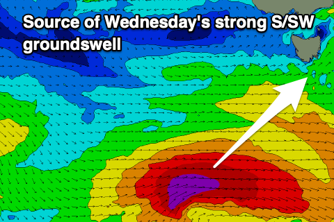
Moving into Wednesday and we’ll see our strong S/SW groundswell filling in, with it being generated by a strong polar low that’s currently south-west of us. A fetch of severe-gale to storm-force W/SW winds are being generated and we should see the swell in the water before dawn and peaking through the morning to a strong 4ft across Clifton.
Winds look good for protected spots with a NW tending variable breeze ahead of SE sea breezes.
 The swell will ease into Thursday but a reinforcing W/SW groundswell will steady wave heights, generated by a good frontal system swinging in from the west and strengthening. A fetch of gale to severe-gale W/NW winds should produce a good 3ft of swell for the afternoon and with NW tending SE winds.
Friday morning will be clean along with easing surf but a polar front will push up and across us into the afternoon, bringing a SW change and new, mid-period SW swell, peaking into Saturday afternoon.
Size wise sets to 3ft are due again but with light SW tending S/SE winds, cleaner Sunday as the swell eases. We’ll review this Wednesday.
Longer term there’s plenty more swell and surf on the cards into next week. More on this Wednesday.

