Unseasonal run of onshore winds
Southern Tasmanian Surf Forecast by Craig Brokensha (issued Wednesday March 30th)
Best Days: No good days
Features of the Forecast (tl;dr)
- Moderate sized mix of W/SW groundswell and mid-period SW swell building tomorrow with strong S/SW tending fresh S/SE winds
- Easing surf Fri with moderate S/SE winds
- Small background swells Sat and Sun with fresh S/SE winds Sat and moderate SE winds Sun
- SW winds Mon with tiny surf
Recap
Tiny surf yesterday and today, ideal for beginners.
This week and weekend (Mar 31 – Apr 3)
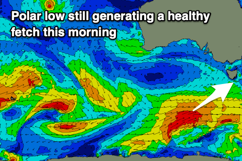
 Our building W/SW swell (from a strong polar low) should be starting to show this afternoon but with poor onshore winds as the low linked to it pushes across the state.
We were still seeing a great fetch of W/SW gales generated in our south-western swell window this morning with a mix of W/SW groundswell and mid-period SW swell due to fill in tomorrow. The groundswell looks to be in the water by the morning with the mid-period energy into the afternoon.
Clifton should see 3ft sets in the morning, with building 3-4ft waves after lunch but with strong, S/SW tending fresh S/SE winds. There'll be nowhere to really recommend unfortunately.
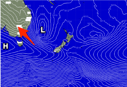
Moderate S/SE winds will linger into Friday as the swells ease back from 3ft on the sets, freshening from the S/SE Saturday as the interaction between a strong high moving in from the west and low drifting south in the Tasman Sea directs S winds across us.
Swell wise a couple of unfavourably tracking polar fronts will keep 1-2ft surf hitting Clifton but with SE winds persisting Sunday, shifting back SW on Monday as a trough moves through.
So all in all we've got a poor run of winds but plenty of swell. Try the East Coast notes for cleaner options over this period.

