Onshore winds spoil the coming swell
Southern Tasmanian Surf Forecast by Craig Brokensha (issued Monday March 28th)
Best Days: No good days
Features of the Forecast (tl;dr)
- Building mid-period W/SW swell Wed with early W tending strong S/SW winds
- Moderate sized W/SW groundswell for Thu with strong S/SE winds, easing Fri with strong S winds
- Onshore S winds Sat with easing surf, smaller Sun with SW winds
Recap
Great surf all weekend with light winds and good pulses of swell, first from the S/SW on Saturday and then SW on Sunday. Today the swell has dropped back quite a bit with tiny leftovers for beginners.
This week and weekend (Mar 29 – Apr 3)
 Tomorrow will be another tiny surf day but heading into Wednesday and more so Thursday some new W/SW swell should fill in.
Wednesday's will be mid-period and more west in nature with a better W/SW groundswell due on Thursday.
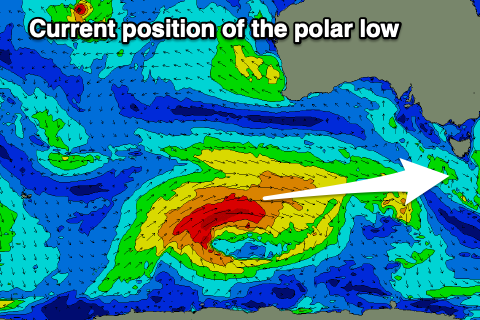
Both these swells are being generated by the same system, that being a strong though polar low moving in from the west.
This low formed south-east of the Heard Island region with an initial fetch of severe-gale W/SW winds but we're now seeing a good fetch of slightly weaker W/SW gales generated through our swell window as it continues east.
It'll push under us on Wednesday morning, bringing a strengthening S/SW change (W'ly early but with no swell).
 This change should come with building sets to 2ft+ later in the day but the groundswell is due Thursday with sets due to build to 3-4ft through the day.
Winds will unfortunately remain poor and strong from the S'th on Thursday as a strong high pressure system edges in from the west, squeezed by a strong low off the East Coast.
The stalling nature of both the high and low will keep poor S/SE winds blowing across our state on Friday as the swell eases, with strong S'ly winds holding Saturday and shifting SW Sunday.
So all in all a poor period of surf with the persistent onshore breeze.
Looking at next week and we'll see polar fronts firing up under us, generating small pulses of SW swell but with generally average winds until Tuesday. More on this Wednesday though.

