Great weekend of surf ahead
Southern Tasmanian Surf Forecast by Craig Brokensha (issued Friday March 25th)
Best Days: Saturday, Sunday, Monday morning, protected spots Thursday
Features of the Forecast (tl;dr)
- Moderate sized, mid-period S/SW swell tomorrow with light N tending S/SE winds mid-late PM
- Reinforcing mid-period SW swell Sun with light N tending weak S/SE winds
- Easing SW swell Mon with N/NW tending S/SW winds late AM, freshening later
- Weak SW swell Tue with light S/SE winds
- Moderate sized + W/SW groundswell Thu with strong W/SW tending SW winds, easing Fri with similar but weaker winds
Recap
Clean, fun levels of mid-period W/SW swell yesterday and today to 1-2ft with clean conditions.
This weekend and next week (Mar 26 – Apr 1)
The weekend is looking really fun with back to back pulses of mid-period swell, both to a similar size.
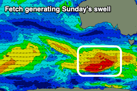
These swells and the past two days of surf have been generated by a progression of healthy polar frontal systems, with the strongest but least favourably aimed currently passing under the state.
An initial polar low generated a fetch of strong to gale-force W/SW winds through the week, producing tomorrow morning's swell which should come in at 3ft, easing through the day.
 The frontal system passing under us today is stronger, but less favourably aligned with a reinforcing pulse to 3ft due on Sunday.
Looking at the local winds and they'll be generally light with with a N'ly offshore tomorrow morning ahead of freshening S/SE sea breezes from mid-late afternoon.
Sunday should see light, variable morning N'ly winds again ahead of weak S/SE breezes, possibly variable into the evening.
Monday morning will be clean again with a N/NW offshore ahead of a trough and late morning/midday S/SW change, weak at first then strengthening into the evening. The surf should still be clean and a fun 2ft.
We should see a small spike in SW swell from the trough bringing Monday's change, with a brief fetch of strong SW winds aimed through our swell window Monday.
A kick to 2ft is likely Tuesday morning, easing through the day but with a light, lingering S/SE breeze.
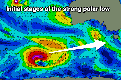
 Moving into the end of the week we've got a strong W/SW groundswell on the cards, generated by a strong polar low forming south-east of the Heard Island region on the weekend.
A great fetch of severe-gale W/SW winds will be generated in our far swell window, with the low weakening while broadening and pushing east closer towards us.
The low will push across us Wednesday bringing a gusty SW change with the swell due to peak Thursday morning to 4ft+ across Clifton but with gusty W/SW tending SW winds. Friday looks similar as the swell eases, but more on this Monday. Have a great weekend!

