Lots of surf days to come
Southern Tasmanian Surf Forecast by Craig Brokensha (issued Wednesday March 23rd)
Best Days: Tomorrow, Friday morning, Saturday, Sunday, Monday morning
Features of the Forecast (tl;dr)
- Mid-period W/SW swell for tomorrow with N/NW tending variable then fresh W/SW winds
- Small surf Fri with NW winds ahead of SE sea breezes
- New moderate sized mid-period S/SW swell Sat AM with variable NW tending SE winds
- Reinforcing SW groundswell Sun AM with N/NW tending SE winds
- Easing surf Mon with N/NW tending gusty S winds
Recap
Monday's pulse of swell faded back into yesterday with tiny, lumpy waves and funky winds, cleaner today but still tiny.
A frontal system moving across us today should be bringing an increase in W/SW windswell this afternoon, with some stronger energy tomorrow.
This week and weekend (Mar 17 - 20)
The frontal system pushing across us today has been generating a healthy fetch of strong W/SW winds through our swell window the past day or so. This should produce some better mid-period W/SW swell tomorrow to 2ft+ across Clifton along with a N/NW offshore, tending variable early afternoon and then fresh W/SW into the mid-late afternoon.
 Friday will be slightly smaller and back to 2ft with NW offshore winds ahead of SE sea breezes.
Following this frontal system will be a stronger fetch of W/SW gales on the polar shelf, generating a fun pulse of new mid-period S/SW swell for Saturday morning, coming in at 3ft, easing through the day.
Conditions should be clean with a variable NW breeze ahead of afternoon sea breezes.
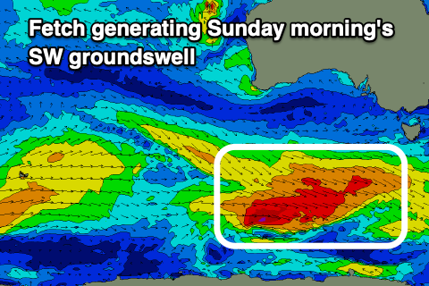
Moving into Sunday we should see our secondary pulse of stronger SW groundswell filling in, generated by a broader, stronger fetch of W/NW gales sliding in through our swell window tomorrow and Friday.
 This swell looks to peak Sunday morning to the 3ft range again across Clifton and with light N/NW winds ahead of sea breezes. Monday morning will be clean but smaller and easing from 2ft and a trough will bring a S'ly change late morning, so surf before then.
Longer term the models diverge regarding additional polar frontal activity moving in from the west so check back here on Friday for a clearer idea on the rest of next week.

