Fun weekend, average next week
Southern Tasmanian Surf Forecast by Craig Brokensha (issued Friday March 11th)
Best Days: Tomorrow until mid-afternoon, Sunday morning
Features of the Forecast (tl;dr)
- Easing W/SW swell tomorrow with N/NW tending gusty S/SE winds from mid-late PM
- Building SW groundswell tomorrow PM, easing Sun with N/NE tending S/SE winds
- Smaller Mon with S/SW winds
- Weak, small W/SW swell Tue with gusty E/SE tending E-E/NE winds, fading Wed with strong NE winds
Recap
Yesterday’s change was delayed and conditions were clean for a period with a drop in size from Wednesday, cleaner today with a fun, reinforcing W/SW swell to 2ft.
This weekend and next week (Feb 12 - 18)
The coming weekend looks fun and well worth making the most of around Clifton before easterly winds kick back in next week.
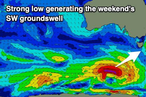
 Today’s swell is due to ease back to 1-2ft tomorrow morning, but into the afternoon a strong new SW groundswell should fill in.
This will be produced by a strong polar low that’s currently south-west of us. A fetch of gale to severe-gale W/SW winds are being generated and this should kick Clifton to 3ft+ later tomorrow evening but morning N/NW winds will give into gusty S/SE sea breezes from mid-late afternoon. There'll be plenty of chances to surf ahead of the sea breeze though.
Sunday looks fun with easing 2-3ft sets and N/NW tending S/SE breezes.
Moving into Monday, a trough will unfortunately bring S/SW winds along with a drop in swell to 1-2ft.
A small, reinforcing pulse of W/SW swell is due on Tuesday, generated by a weak, trailing fetch of W/SW winds trailing the polar low linked to the weekend’s swell. This should maintain 1-2ft sets but winds look to remain an issue, fresh from the E/SE tending E/NE-E, favouring only a select few locations.
Winds should swing around to the NE on Wednesday creating cleaner conditions but with fading surf from 1ft+. NE winds look to persist into the end of the week as the swell bottoms out.
Longer term there’s a bit of storm activity due to the south-west of Western Australia but at this stage it looks a little too far north and west to generate any significant size for us. More on this in next week’s updates. Have a great weekend!

