Good swells with improving winds from Friday
Southern Tasmanian Surf Forecast by Craig Brokensha (issued Wednesday March 9th)
Best Days: Friday morning, Saturday, Sunday morning, Tuesday afternoon selected spots
Features of the Forecast (tl;dr)
- Drop in swell tomorrow with fresh S/SW winds
- Reinforcing W/SW swell Fri with W/NW tending W/SW tending S/SE winds
- Strong SW groundswell building Sat PM with N/NW tending S/SE winds, easing Sun with similar winds
- S/SE winds Mon with a building W/SW swell, easing Tue with E/SE tending E/NE winds
Recap
Poor surf yesterday with tiny waves and onshore winds, but our new swell today is providing good clean 2-3ft sets with favourable morning winds.
This week and weekend (Mar 10 - 18)
Tomorrow will be another lay day as a low off the southern NSW coast shifts east, dragging S/SW winds in behind it, across our state. The swell will ease back to the 2ft range but there'll be nowhere to recommend.
Winds should shift back to the W/NW on Friday morning but with onshore winds into tomorrow evening and early in the morning it might be a little lumpy.
 A good reinforcing W/SW swell is due Friday owing to a healthy, trailing fetch of strong W/NW winds on the tail of the low linked to today's swell.
This should come in around 2ft but surf before mid-late morning when winds shift back W/SW and S/SE into the afternoon.
Conditions will be cleaner for longer Saturday morning with a light N/NW offshore ahead of S/SE sea breezes.
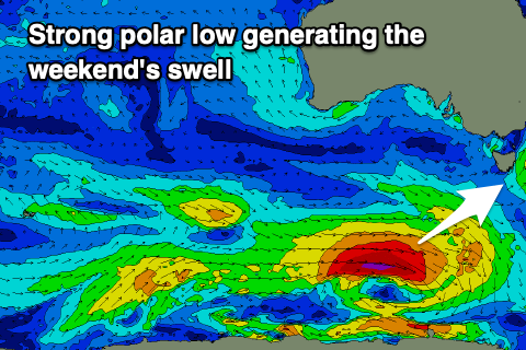
Later in the day on Saturday a strong new SW groundswell is due, with it due to peak overnight and ease through Sunday.
The source of this swell will be a strong polar low firing up south-west of us tomorrow, generating a fetch of gale to severe-gale W/SW winds through our south-western swell window.
 Sets should kick to a strong 3ft Saturday afternoon, then easing 3ft from Sunday morning on the sets, but likely mostly 2-3ft. Conditions will be great with a light N/NW offshore before S/SE sea breezes kick in again.
Into early next week winds look to be less than ideal and S/SE in the wake of a trough Sunday evening, shifting fresher E/SE to E/NE as a high quickly slides in from the west. This will be along with some fun, mid-period W/SW swell from a weaker fetch of W/SW winds trailing the low linked to the weekend's swell. Following this the outlook goes quiet into the end of the week so make the most of the coming surf days.

