Good surf continues
Southern Tasmanian Surf Forecast by Craig Brokensha (issued Monday February 21st)
Best Days: Tomorrow, Wednesday, Thursday morning for beginners, Saturday morning, Sunday for beginners, each morning next week (excluding Monday)
Features of the Forecast (tl;dr)
- Moderate sized, mid-period SW swell easing tomorrow with light N/NE tending strong W/NW winds, smaller Wed
- Reinforcing S'ly groundswell filling in Wed, peaking in the PM with moderate N/NE tending strong E/NE winds
- Easing S groundswell Thu with variable tending increasing S/SE winds
- Small W/SW swell Sat AM with NE tending E/NE winds, fading Sun
- Small SW swells next week with light winds each morning
Recap
Great surf all weekend with Friday's strong swell easing and cleaning up with sets to 2-3ft Saturday morning, while a reinforcing swell maintained 2ft+ waves through yesterday. Today the swell is clean again and a fun 2ft across Clifton with fresh NW winds ahead of a change.
This week and weekend (Feb 22 - 27)
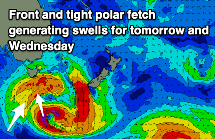
 Today's strengthening winds are linked to a strong cold front pushing up and across us, bringing some fun new, mid-period SW swell later today and more so tomorrow.
A good fetch of strong to near gale-force S/SW-SW winds are being generated, with a stronger fetch of S'ly gales at the base of the progression.
This should result in a moderate sized SW swell for tomorrow, with a reinforcing S'ly groundswell for Wednesday afternoon.
Size wise, tomorrow should come in at 3ft, easing through the day with Wednesday holding 2ft, kicking to 2ft+ into the afternoon with the new S'ly swell. This pulse of swell will be short-lived, easing rapidly Thursday from 1ft+.
Conditions will be favourable with light N/NW offshore tomorrow ahead of strong afternoon E/NE winds, moderate N/NE tending strong E/NE winds on Wednesday.
A trough looks to move through Thursday morning but early winds should be variable and offshore, fresher S/SE into the afternoon.
 Friday looks to be a lay day as tiny surf persists with a lingering S'ly breeze, better Saturday with a new pulse of small W/SW swell. A tight mid-latitude front should generate a fetch of strengthening W'ly winds while approaching us, generating 1-2ft surf for Saturday morning under a NE breeze.
From Sunday through early-mid next week, a strong high slowly moving across us will bring persistent E'ly winds, which look lighter each morning, and some fun pulses of mid-period swell are due from healthy polar frontal activity moving in and under the country.
This should produce small pulses of swell in the 2ft+ range, but more on this in Monday's update.

