Building swell and winds over the coming days
Southern Tasmania Surf Forecast by Craig Brokensha (issued Wednesday February 16th)
Best Days: Late tomorrow, dawn Friday, Saturday, Sunday morning, Tuesday morning
Features of the Forecast (tl;dr)
- Building mid-period W/SW swell tomorrow afternoon with gusty W/SW winds, tipping back NW late
- Building mix of W/SW groundswell and mid-period swell Fri, peaking into the PM with early fresh W/NW tending strong W/SW then SW winds
- Easing mix of swells Sat with N/NW tending fresh E winds
- Reinforcing W/SW swell Sun with N/NW tending S/SE winds
- Weaker W/SW swell Mon PM and Tue with onshore winds Mon, cleaner Tue AM
Recap
Not much in the wave of surf reported yesterday with tiny bumpy options, cleaner and better today with a reinforcing swell and sets to 1-2ft across Clifton.
This week and weekend (Jan 17 - 20)
Tomorrow will start tiny but a strong cold front pushing under us through the day should kick up a weak 1-2ft of W/SW swell into the afternoon. Conditions will be bumpy though with a moderate to fresh W/SW breeze, improving late as winds shift back to the NW ahead of another approaching front.
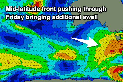
This secondary front will be linked to our mid-period W/SW swell that’s due to fill in Friday afternoon, on top of an inconsistent W/SW groundswell.
 The groundswell was generated by a strong, slow moving polar low firing up east of the Heard Island region earlier this week, with the swell building slowly through Friday from 2-3ft in the morning with the swell peaking to 3ft+ into the afternoon. The additional mid-period W/SW swell looks to be around 3ft and we’ll likely see the combining and coming in at 3-4ft through Friday afternoon.
Winds look to deteriorate through Friday with early fresh W/NW winds tending strong W/SW mid-morning and holding from the SW into the afternoon. Saturday looks the pick with a N/NW offshore in the morning ahead of E’ly sea breezes with an easing mix of swells from the 3ft range.
We should see some reinforcing W/SW swell energy from weaker, trailing frontal systems and this should maintain 2-3ft sets across Clifton on Sunday under a morning N/NW breeze ahead of afternoon S/SE sea breezes.
Longer term, Monday looks a touch smaller but another weak front should bring some new W/SW swell for the afternoon and Tuesday with unfavourable winds on the former, better on the latter. More on this in Friday’s update.

