Upgrade in swell prospects for next week
Southern Tasmania Forecast by Craig Brokensha (issued Friday 17th July)
Best Days: Beginners on the weekend, protected spots Monday afternoon, Tuesday morning, Wednesday, later week
Recap
Tiny and clean options for beginners.
This weekend and next week (Jul 18 - 24)
The weekend will remain tiny and clean, ideal for beginners with a very infrequent W/SW groundswell due to build tomorrow and ease Sunday with freshening N/NE winds.
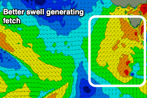
Moving into early next week and we’ve got an upgrade in swell due off a strengthening mid-latitude system pushing across us Monday. The initial stages of this storm is currently a polar front south-west of WA and it’ll push up towards and through the Bight before moving across to us.
 On the tail of the system, a strengthening polar front will project north-east and combine, with a fetch of strong S/SW winds forecast to be aimed up and into us through Monday.
This will bring a stormy increase in SW swell Monday, reaching 3-4ft by dark, and then easing from 3-4ft on Tuesday from a S/SW direction.
Winds Monday will swing strong W/SW-SW around dawn and then possibly back to the W/NW later in the day (unlikely), holding out of the W Tuesday before then tending W/SW through the afternoon.
Wednesday will be smaller but cleaner with W/NW-NW breezes and then we may see some new S/SW swell developing later week as a polar front develops south of us mid-week.
More on this Monday though. Have a great weekend!

