An increase in activity, solid next week
Southern Tasmania Surf Forecast by Craig Brokensha (issued Friday 3rd July)
Best Days: Saturday morning, Monday, Tuesday morning, Wednesday, Thursday
Recap
Tiny to flat conditions yesterday but today our new mid-period W/SW swell has kicked up some small 1-1.5ft waves for the keen.
This weekend and next week (Jul 4 - 10)
A peak in the W/SW energy is due this afternoon across Clifton with possible 2ft sets in the mix, and we'll see this swell ease tomorrow from a similar size (1-1.5ft with possible 2ft sets).
 There'll also be some weak S/SW windswell in the mix generated by a cold front that's currently pushing across us, generating sets to 2ft or so, while a secondary push up and into us tomorrow afternoon should maintain 2ft waves Sunday, easing from 1-1.5ft Monday.
Winds look favourable tomorrow morning and N/NW ahead of a strong SW change and now less favourable from the W/SW-SW on Sunday. Monday looks clean again with morning N/NW offhshores ahead of a W'ly change.
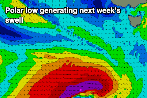
We then look to a great looking low that's forecast to develop well south of WA tomorrow evening, dipping east-southeast while generating a great fetch of severe-gale to storm-force W/SW winds along the polar shelf.
The low will be slow moving, generating a large, long-period SW groundswell for Tuesday, swinging more S/SW Wednesday while easing slowly.
It's looking like we'll see sets hitting 4ft+ across Clifton Tuesday but with W tending SW winds, easing slowly from 4ft Wednesday under N tending N/NE winds.
We'll have a closer look at this on Monday though. Have a great weekend!

