Good run of conditions and swell
Southern Tasmania Surf Forecast by Craig Brokensha (issued Monday 15th June)
Best Days: Tuesday, Wednesday, Thursday, Saturday, Sunday morning
Recap
Nothing of note over the weekend but today we've seen some new W/SW groundswell on the build from 1-2ft this morning. More size is being seen this afternoon with great conditions.
This week and weekend (Jun 16 - 21)
It's a little tricky coming off a cold start, but I've stuck with Ben's outlook for swell for tomorrow.
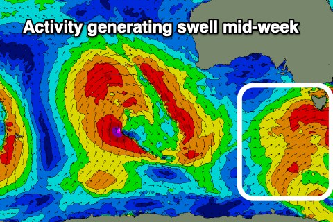
We've got slowly building levels of W/SW groundswell from a strong conveyer belt of frontal systems through our swell window the last few days.
 Inconsistent sets to 2-3ft should have been seen later today, with the size expected to hold tomorrow, with a better and more consistent increased slated for Wednesday. This will be generated by the strongest and closest (in proximity) of the fetches moving through our swell window tomorrow.
A kick to 3ft+ should be seen across Clifton Wednesday, easing back slowly from 2-3ft on Thursday.
Conditions through this period look great with gusty NW tending W/NW winds tomorrow, NW tending lighter W/NW winds Wednesday and then N/NW tending N/NE winds on Thursday.
It looks like we'll see a low point in swell on Friday, but moving into Saturday, a new S/SW groundswell is expected off a polar fetch of W/SW gales forming south-west of us Thursday. While relatively small in scope the strength should produce a good kick Saturday to 2-3ft (possibly a touch undersized early), then easing from 2ft on Sunday.
Winds look generally favourable and N/NE on Saturday, N/NW tending variable on Sunday, but we'll confirm this Wednesday.
Longer term there's nothing too significant with mid-latitude systems due to develop too north of our swell window, but more on this Wednesday.

