The run of swell continues
Southern Tasmanian Surf Forecast by Craig Brokensha (issued Friday 5th June)
Best Days: Saturday morning, Sunday, Monday morning, Wednesday morning
Recap
A drop in swell from Wednesday yesterday morning with favourable winds for selected breaks, back to 2ft this morning and nice and clean.
This weekend and next week (June 6 – 12)
There’s no change to tomorrow’s new S/SW groundswell with the polar low linked to it, now weakening south of us and pushing east.
We should see 3ft to possibly 4ft sets across Clifton, easing through the day with a shift in winds back to the W/NW after this afternoon’s change, shifting W/SW through the afternoon.
 Sunday looks fun still with the reinforcing mid-period swell from a trailing front behind the polar low due to keep Clifton around 2-3ft.
NW winds will create clean conditions, shifting W/NW ahead of a possible shift to the W/SW later in the day.
Monday will be smaller and easing from 2ft on the sets with all day offshore NW winds.
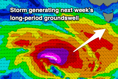
Moving into the middle of the week, and a strengthening polar low will generate a fetch of severe-gale to storm-force W/NW winds through our swell window Monday afternoon through Tuesday evening, with a long-period SW groundswell due to spread up and into us Wednesday.
While not on the ideal track, the strength should see a good 3-4ft of swell building into Wednesday afternoon, then easing Thursday. Conditions at this stage look favourable Wednesday morning with a N/NW offshore, giving into an afternoon S’ly change, which will then linger Thursday.
We’ll have a closer look at this on Monday though. Have a great weekend!

