Multiple swells sources on the way
Southern Tasmania Surf Forecast by Craig Brokensha (issued Monday 1st June)
Best Days: Tomorrow afternoon, protected spots Wednesday, Thursday, Friday, Sunday
Recap
A tiny start to Saturday but a new swell kicked in through the day as winds held out of the north, tiny, clean and easing yesterday, similar today.
This week and weekend (Jun 2 - 7)
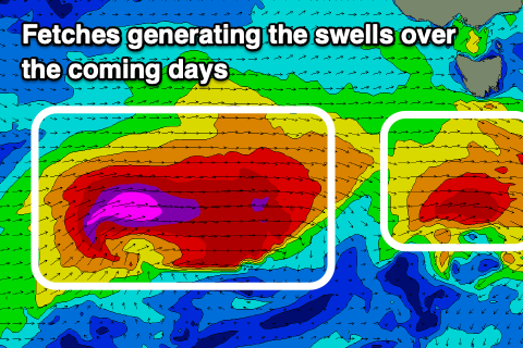
Currently we've got a couple of good and strong frontal systems heading our way, the first is directly south-west of us and generating a fetch of W/SW gales.
 This should pass under us this evening, with the swell arriving from it tomorrow afternoon, building to at least 2ft+ if not 2-3ft by dark.
Of greater significance is the stronger front behind it, with a fast moving fetch of severe-gale to storm-force W/SW winds currently pushing east through our western swell window. While the fast track isn't ideal. the strength is.
This front will weaken while pushing across and then up and over us tomorrow evening and Wednesday, with a trailing fetch of strong S/SW winds through our southern swell window.
A larger W/SW groundswell is due from this source, building Wednesday afternoon and easing Thursday, with localised windswell in the mix ahead of this.
Clifton should come in around 4ft or so Wednesday, and then ease from 3-4ft on Thursday with some S/SW swell in the mix.
Winds look favourable most of tomorrow and N/NW, tending NW, with Wednesday poor as the front moves through bringing strong S/SW breezes.
 Thursday looks excellent as the mix of W/SW and S/SW swell ease with N/NW tending variable winds.
We've then got a fun new S/SW groundswell on the cards for the weekend, generated by a deepening polar low south-west of us on Thursday. A good fetch of severe-gale W/SW winds will be produced through our southern swell window, and we may see a late kick in size Friday but Saturday morning should reveal the size with 3-4ft sets across Clifton, easing into the afternoon.
Winds unfortunately go onshore Saturday as a surface trough moves through, linked to the polar low generating the swell, cleaner Sunday as the swell eases.
Longer term there's a possible good swell mid-next week, but we'll have a closer look at this Wednesday.

