Large swell to end the week
Southern Tasmania Surf Forecast by Craig Brokensha (issued Wednesday 20th May)
Best Days: Next Wednesday
Recap
Tiny waves ideal for beginners and fun boards yesterday, even smaller today.
This week and weekend (May 21 - 24)
After the easing surf of the last couple of days, we now look at the large, long-period SW groundswell due into the end of the week.
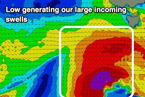
Currently a strong polar low has formed south-west of us with a fetch of severe-gale W/SW winds due to project through our swell window today, with a burst of storm-force SW winds at the base of the low this evening.
We'll see the low continue slowly east through tomorrow will continuing to generate a fetch of severe-gales in our swell window.
 A long-period SW tending S/SW groundswell is due to build tomorrow but peak Friday morning across Clifton.
Tomorrow morning looks to be around 2ft+ or so, building to 4ft+ later in the afternoon with Friday seeing sets to 4-5ft+, easing slowly through the day and then down further from 3ft+ Saturday morning.
Conditions are looking good mostly with NW tending less favourable W/SW winds tomorrow, much better Friday and N/NW tending variable NE.
Get in early Saturday as early variable winds are expected to give into a change mid-morning.
The swell should continue to ease Sunday but a small and tight low moving in and under us Saturday looks to generate a small pulse of SW swell to 2ft+, Winds will be onshore from the S/SE still in the wake of Saturday's change.
There's then nothing significant on the cards for nearly all of next week as the storm track focusses north and up into Western Australia and South Australia. Therefore make the most of the coming swell.

