New swell from mid-week
Southern Tasmania Surf Forecast by Craig Brokensha (issued Monday 11th May)
Best Days: Beginners tomorrow, Wednesday morning, Thursday, Saturday, Sunday
Recap
Our new pulse of S'ly groundswell came in at 2-3ft across Clifton Saturday and with better than expected conditions, replaced by a new W/SW groundswell yesterday but with less than ideal conditions.
Today was much cleaner with easing 2ft sets but closeouts on the morning low tide.
This week and weekend (May 12 - 17)
Any swell seen left into today will fade tomorrow leaving tiny waves on the Coast with fresh N-N/NE tending N/NW winds.
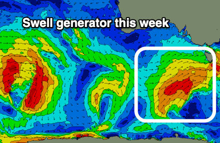
The new SW swell flagged last Friday for Wednesday is on track, with the remnants of a good frontal progression moving in from the west expected to strengthen south-west of us tomorrow.
 A fetch of strong to near gale-force SW winds will be projected up towards us, weakening as the front moves across us Wednesday. A fun sized SW swell should build Wednesday from a small 1-2ft or so in the morning, reaching 3ft through the afternoon.
Winds will unfortunately swing onshore with the swell generating front, from a morning NW'ly around to the W/SW and strong into the afternoon, better Thursday and back to the N/NW as the swell eases from 2-3ft.
The surf will continue to fade into Friday and bottom out Saturday but following this we'll see a conveyer belt of Southern Ocean fronts moving in from the west, with one embedded system possibly bringing a good pulse of W/SW groundswell for Sunday.
The models are still divergent regarding this though so check back here Wednesday for more details.

