Small westerly swells to persist
Southern Tasmania Surf Forecast by Craig Brokensha (issued Wednesday 22nd April)
Best Days: Tomorrow, Saturday, early Sunday, Monday, Tuesday
Recap
Tiny surf yesterday with a flukey and very W swell, a touch better today though windy with a strong low pushing in and under us. We should see sets reaching 3ft+ later today but conditions will remain average.
This week and weekend (Apr 23 – 26)
The strong low linked to this afternoon's swell pulse will ease off steadily tomorrow owing to the low moving under us today and swinging the swell generating fetch more westerly.
Easing sets from 2ft+ are expected, tiny into the afternoon but with offshore N winds. Friday will be clean again but tiny.
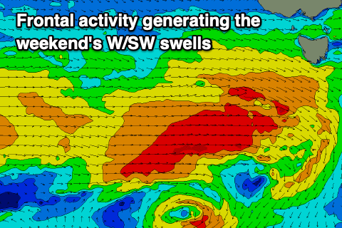
 We've got more W/SW swell due into the weekend, generated by a strengthening cold front to our west-southwest Friday.
A good fetch of strong to gale-force W-W/SW winds should produce a small, fun W/SW swell for Saturday to 1-2ft across Clifton, holding Sunday morning.
Background and less consistent energy should keep Clifton around 1-2ft into the afternoon, while a weak front moving in and under us Monday will provide similar sized waves into Monday.
Tuesday morning may see a bit more consistent size to 2ft owing to a burst of W'ly gales moving in Sunday evening but we'll review this Friday.
Conditions through the weekend and early next week will remain favourable with persistent N'ly offshores, though a W/sW change is due mid-morning Sunday, back offshore for Monday and Tuesday.
Longer term the storm track will stay north of our swell windows until possibly late in the week, but check back here on Friday for an update on this.

