Windy and solid tomorrow, swells from the west next week
Southern Tasmania Surf Forecast by Craig Brokensha (issued Friday 17th April)
Best Days: Saturday, Sunday morning, Tuesday afternoon, Wednesday, Thursday
Recap
Small and clean waves yesterday with an inconsistent SE groundswell, while today a new W'ly swell has filled in with 2-3ft sets across Clifton with a W'ly wind. Later today some additional W/SW swell may be seen from a strong front pushing up and into us but tomorrow will reveal the most size.
This weekend and next week (Apr 18 – 24)
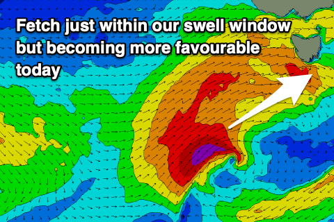
Our large SW groundswell for tomorrow is still on track, with a tight and embedded low that's currently south-west of us generating a fetch of severe-gale SW winds that are just within our swell window.
 The low will move more ideally into our swell window during the day while projecting up and into us, generating a large pulse of SW groundswell for tomorrow morning with 4-6ft sets across Clifton, easing into the afternoon and much smaller and easing from 2-3ft Sunday.
With the low pushing into us we'll see fresh to strong W/SW winds tomorrow, light W/NW-NW Sunday morning ahead of sea breezes, tiny Monday with strong N/NE winds.
Into mid-next week, a strong but poorly aligned mid-latitude storm is forecast to deepen south of the country but just a touch too north for us.
 We'll see a great fetch of gale to severe-gale W'ly winds projected through our western swell window Monday, with a very acute W'ly groundswell due to build Tuesday and peak Wednesday morning.
Size wise we're not looking much over 2ft across Clifton at this stage.
A secondary front forming on the backside of this storm may generate a better W/sW swell for Thursday, but we'll have to have a closer look at this on Monday. Have a great weekend!


Comments
Wonder how many 1000's of people are off to surf marginal points tomorrow morning. Will they be able to stay 1.5 m away from each other? Can you snake at 1.5m or will you be on the rocks?
They can snake under, !around and even through the rocks!