Small westerly swells
Southern Tasmania Surf Forecast by Craig Brokensha (issued Monday 30th March)
Best Days: Tomorrow from midday, Wednesday, Thursday morning, Friday morning
Recap
Fun and clean surf to 2ft on Saturday, fading Sunday and becoming tiny. Today is still tiny with no new swell.
This week and next (Mar 31 – Apr 5)
The coming days are the best of the period until things get windy and stormy next week.
Our new inconsistent and long-period W/SW groundswell is on track, with a distant but strong polar low firing up east of Heard Island on Friday evening and into Saturday.
 Satellite observations picked up a great fetch of severe-gale to storm-force W/SW winds, with the swell due to arrive through tomorrow morning and build to an infrequent 2ft+ through the afternoon.
Conditions look good all day with a N/NW tending N-N/NE offshore, with Wednesday seeing N/NW tending SE winds as the swell eases from 2ft.
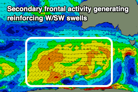
Into the afternoon a new reinforcing W/SW groundswell is due, produced by a broad front that's currently south of WA, though due to its westerly bias only 2ft sets are likely.
Behind this weaker but more favourably aligned fetches should keep 1-2ft waves hitting Clifton through Thursday and Friday, easing into the weekend.
Winds Thursday morning look to be E/NE, possibly shifting N/NE for a period ahead of sea breezes with N/NW tending E/SE winds Friday.
There's nothing significant due on the weekend and moving into next week, we're expected to see a strong mid-latitude low moving in slowly from the west.
The models diverge on the speed and position of this low, with GFS having it slower and further north but combining with a polar front early next week, while EC has this occurring quicker and into Sunday. Either way any swell will arrive with wind and it's not looking very good in quality at all.
We'll have a closer look at this Wednesday.


Comments
Sunday is looking big? Like biggest one we have had this year yeah? But not appearing on your models?