Lots of swell to come from late week
Southern Tasmania Surf Forecast by Craig Brokensha (issued Monday 16th March)
Best Days: Tuesday morning, Friday, Saturday morning, Monday, Tuesday and Wednesday mornings next week
Recap
Plenty of surf but not the cleanest conditions on Saturday with 2-3ft of swell, back to 1-1.5ft on Sunday with lingering onshore winds.
Today conditions are cleaner with 1-1.5ft of swell, under the expected kick in size to 2ft to possibly 3ft through the day.
This week and weekend (Mar 17 - 22)
Any swell seen today is due to ease back tomorrow, with 1-2ft sets for the keen along with great conditions under a fresh offshore N'ly tending late NE breeze.
Wednesday will be clean again but tiny as the swell bottoms out, similar Thursday but with only a morning offshore.
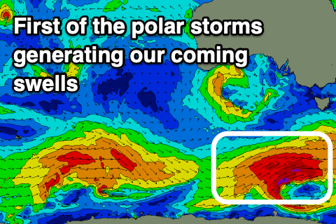
 From the end of the week though we've got plenty of swell on the cards as a flurry of strong polar fronts fire up under the influence of a strong node of the Long Wave Trough moving in from the west.
The first polar front is due to fire up over the coming days, generating a great fetch of gale to severe-gale W/SW winds while projecting ideally through our south-western swell window.
A moderate sized long-period SW groundswell should be seen, filling in Friday and offering solid 3-4ft sets across Clifton with N tending NW winds ahead of a late W/SW change.
The swell will ease into Saturday with the next solid spike in energy due through Sunday, just under Friday's pulse in size. This will be generated by a good fetch of severe-gale W'ly winds in our swell window, generating 3ft+ of groundswell with similar pulses around that size due secondary fronts firing up along the polar shelf.
Winds look dicey Sunday and onshore from the W/SW better Monday and Tuesday mornings and NW. More on this Wednesday though.

