Small, fun W/SW swell from later Sunday
Southern Tasmania Surf Forecast by Craig Brokensha (issued Friday 24th January)
Best Days: Monday, Tuesday, Wednesday morning
Recap
Tiny waves yesterday and similar today with the swell too west to impact us.
This weekend and next week (Jan 25 – 31)
The weekend will remain tiny to flat for the most part, but later Sunday a new pulse of W/SW groundswell should be seen, with further and better pulses through Monday and Tuesday.
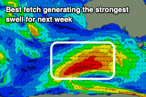
 As touched on the last couple of updates. A strong polar low forming south of WA is now generating a good fetch of W/SW gales in our western swell window and we'll see this fetch project towards us today before weakening tomorrow as a secondary slightly more northerly positioned fetch piggy-backs over the top tomorrow afternoon and Sunday morning.
A good W/SW groundswell is due off the current fetch, building later Sunday to 2ft, and holding a similar size Monday, if not for the odd sneaky bigger one at times.
The secondary slightly more northerly positioned fetch will generate a stronger W/SW groundswell but it'll be a little more west in nature, peaking Tuesday morning to 2ft to occasionally 3ft, easing later in the day and then down from 1-2ft on Wednesday.
Conditions will be favourable Sunday morning but average into the afternoon with S/SE sea breezes, N/NW most of Monday ahead of a late afternoon W/SW change, N/NW Tuesday and swinging SW mid-afternoon. Wednesday should be clean again ahead of sea breezes.
As touched on last update, the outlook into the end of the week and next weekend is poor with no decent swell due into the following week. More on this Monday. Have a great weekend!

