Shot-lived spike in swell on the weekend
Southern Tasmania Surf Forecast by Craig Brokensha (issued Friday 3rd January)
Best Days: Protected spots Sunday, Monday morning, Wednesday morning, Thursday morning
Recap
Nothing of note yesterday or today.
This weekend and next week (Jan 4 - 10)
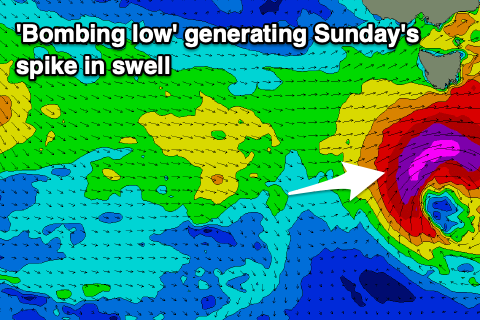
Tomorrow will remain tiny to flat, but we'll see a 'bombing low' forming directly south-west of us, with a fast moving fetch of severe-gale to storm-force W/SW winds tracking east under us.
The fast moving nature of the low makes it tricky to forecast and our models aren't capturing it well.
 We'll hopefully see the swell spike Sunday morning to 3-5ft, but be much smaller either side of this spike, easing rapidly Monday and back from 1-2ft.
Winds on Sunday look W'ly, shifting onshore SW-S through the day, clean Monday morning ahead of sea breezes.
We then look towards some new W/SW groundswell due mid-week, generated by the remnants of a tropical cyclone, that being Calvinia being absorbed into the westerly storm track from a position off Madagascar earlier this week.
As it tracks further south it'll turn into a polar low and we'll see a fetch of strong to gale-force W/SW winds generated in our western swell window.
A fun pulse of swell should be seen, later Tuesday but more so Wednesday to 2ft to possibly 3ft. A morning N/NE offshore is expected Wednesday morning ahead of sea breezes, stronger Thursday as the swell eases ahead of a late change.
Longer term there may be some new swell on the cards for next weekend, but more on this Monday. Have a great weekend!

