Tiny ahead of some better W/SW swell mid-week
Southern Tasmania Surf Forecast by Craig Brokensha (issued Friday 27th December)
Best Days: Beginners tomorrow morning, later Tuesday, Wednesday, Thursday morning
Recap
Nothing to surf yesterday and a tiny swell today.
This weekend and next week (Dec 28 – Jan 2)
A touch more swell is likely tomorrow with a frontal system passing under us today generating 1ft+ of swell which will fade through the day. Conditions should be clean with a N/NE breeze, giving into gusty S/SE sea breezes.
Sunday will be minimal in swell and we then look onwards to the swells due next week.
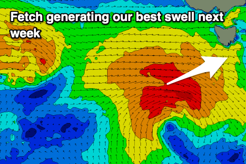
 Monday morning will start tiny, but a strong frontal progression that's currently south-west of WA is generating a great fetch that might just be in our swell window.
It's strong but very west and as a result we may see 1ft+ of W/SW groundswell late Monday, and Tuesday morning. Winds on Monday are tricky likely N'ly ahead of E/SE sea breezes but possibly going variable late ahead of a change.
Tuesday looks average with W/SW breezes, improving and tending W/NW through the day.
Some better mid-period W/SW swell is on the cards for later Tuesday but more so Wednesday as a broader but weaker mid-latitude storm moves in from the west.
A fetch of strong W/SW winds will move through our western swell window, with 2ft to possibly 3ft sets expected across Clifton Wednesday morning, easing through the day, holding 2ft Thursday as another front pushes through.
Winds on Wednesday look better and N/NW tending W/NW, W/NW Thursday morning ahead of S'ly sea breezes. More on this Monday though. Have a great weekend!

