Large windy swell for the coming days
Southern Tasmania Surf Forecast by Craig Brokensha (issued Friday 20th December)
Best Days: Selected spots Sunday and Monday, Tuesday morning
Recap
Poor and building surf yesterday, peaking this morning to 2ft with light winds though sloppy conditions before freshening from the NE.
This weekend and next week (Dec 21 - 27)
Tomorrow looks poor with no decent swell and with onshore W/SW winds.
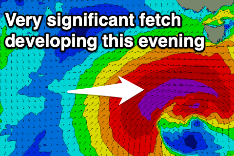
We then look towards the deep and intense low currently forming south-west of us, with it on track to deliver a large and powerful long-period W/SW groundswell on Sunday, easing slowly thereafter while swinging more SW-S/SW in direction.
 This afternoon and evening, an impressive fetch of storm-force W/SW winds develop and project east through our western swell window, moving more into our south-western swell window tomorrow evening while weakening.
There's no change to the expected size, with possibly a slight upgrade, coming in at 5-6ft+ across Clifton on Sunday. Winds aren't ideal and due to fresh from the W Sunday morning, shifting W/SW-SW and then S/SE.
Come Monday the swell will still be large and tending more SW-S/SW in direction and easing from the 4-5ft range though with onshore SW winds and S/SE sea breezes.
Tuesday should continue to offer a bit of size but winds will linger onshore out of the S'th, easing from 2-3ft. It'll still be worth a surf though with the size and direction of the swell. Wednesday will be clean but tiny and to 1ft+ or so.
Longer term there's nothing significant on the cards so try and work the swell and winds this period.

