Poor week, lots of swell into the weekend
Southern Tasmania Surf Forecast by Craig Brokensha (issued Monday 16th December)
Best Days: Friday morning, protected spots Sunday and Monday, Tuesday morning
Recap
Tiny and onshore Saturday, clean and ideal for beginners yesterday, holding 1ft today but with more flukey winds and a little bumpy.
This week and weekend (Dec 17 - 22)
The outlook for this week hasn't changed with no significant surf on the cards at all.
A lift in size shown later Thursday and Friday on the forecast charts is over-forecast a touch. A weak front passing under us Thursday should kick up a tiny pulse of size for later in the day to 1-1.5ft, easing from a similar size Friday morning.
Conditions will be poor as the swell builds Thursday afternoon with gusty S/SW winds, N/NE on Friday morning favouring some spots, but not others.
 Of greater importance are the developments into the weekend.
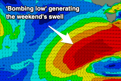
As touched on in Friday's update, a significant storm is forecast to develop under the state, with this now being classed as a 'bombing low'.
A couple of low pressure centres west-southwest of WA are expected to track south-east, with one of them dropping over 24hPa in central pressure in less than 24 hours, classifying it as a 'bombing low'.
The low will drop to 961hPa south-southwest of us, with a fetch of severe-gale to storm-force W/SW winds forming on its northern and western flank, moving slowly east through our western swell window and then south-western into Sunday.
A prolonged W/SW tending SW groundswell event is due from this low, building later Saturday but peaking Sunday to the 4ft+ range across Clifton, possibly coming in a little bigger and to 4-5ft Monday morning out of the SW and then easing, back to 2-3ft Tuesday.
Winds will strengthen from the W on Saturday, with W/NW tending W/SW winds on Sunday, W/SW tending S on Monday and possibly lingering onshore winds from S/SE on Tuesday. We'll have a closer look at this swell and the expected size on Wednesday.

