Plenty of swell into next week
Southern Tasmania Surf Forecast by Craig Brokensha (issued Wednesday 27th November)
Best Days: Early Friday, Saturday morning beginners, next week
Recap
Tiny waves yesterday and onshore winds, cleaner today but near flat.
This week and weekend (Nov 28 – Dec 1)
There's been no real change to the W/SW swell expected tomorrow and Friday across the state.
A slow moving and relatively weak low moving in from the west has generated a fun W/SW swell for the coming days. The swell should build through tomorrow, reaching 2ft+ into the afternoon, and then easing from a similar size Friday morning, if not more so 2ft.
Winds will be less than favourable tomorrow as the swell builds and shifting W/SW at dawn and then giving into S/SE sea breezes.
Friday is the pick as the swell eases under a dawn NE tending NW wind ahead of a gusty S'ly change mid-late morning. EC has onshore winds from dawn still, but all the other models are going against this, event the hi-res Access-R which is the most reliable at this point in time.
 Saturday may see a tiny 1ft+ leftover and with more variable winds ahead of sea breezes.
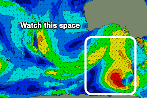
Of greater import is the activity into next week, all owing to a strong node of the Long Wave Trough stalling east of us.
This will direct a flurry of polar fronts initially up through our south-western and western swell windows, with the activity moving more into our southern swell window mid-late week.
The first of the frontal systems will move through our swell window at polar latitudes on Saturday before pushing up into SA. This should produce a small increase in W/SW swell for Monday, kicking to 2ft+ or so later in the day, while a slightly better aligned and stronger polar fetch should produce a better increase in size Tuesday to 3ft or so into the afternoon.
Following this a drawn out and persistent fetch of strong W/SW winds will generate a bigger W/SW swell for Wednesday afternoon and and Thursday, but we'll have to nail down the specifics on Friday.
Winds will be strong and generally from the W/NW tending W/SW, but more on this next update.

