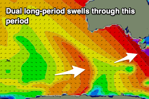
Lots of swell to come from the weekend
Southern Tasmania Surf Forecast by Craig Brokensha (issued Wednesday 25th September)
Best Days: Thursday morning, Saturday, Sunday morning, Tuesday
Recap
The surf hung around a small 1-2ft yesterday, a bit better than expected, while a new S/SW swell has filled in today offering 2-3ft sets through the day with light morning winds ahead of sea breezes.
This week and weekend (Sep 26 - 29)
Today's S/SW swell should ease back in size through tomorrow, dropping from 1-2ft and then tiny Friday morning. Conditions will be good tomorrow morning with a N/NW offshore and E/SE sea breezes, and then N tending SW winds Friday.
Our new inconsistent W/SW groundswell for Saturday is still on track, with it due to arrive late Friday and peak Saturday to an infrequent 2ft to occasionally 3ft across Clifton as winds shift back to the NW, W/NW into the afternoon.
The swell is due to drop back into Sunday, though a pre-frontal fetch of strong to gale-force W'ly winds will generating a reinforcing W/SW swell to 2ft+.
 Of greater importance is the larger swell due into Monday, produced by a stronger polar low moving in from the west over the coming days.
A fetch of severe-gale W'ly winds will be initially generated before the storm weakens slowly while moving closer towards us on the weekend.
A moderate sized W/SW groundswell is due off this low, peaking Monday morning to 4ft across Clifton, mixed in with consistent mid-period SW energy from the low moving under us Sunday.
Winds are still looking dicey Monday and light to moderate W-W/SW in the wake of the low, fresher SW into the afternoon.
Tuesday will clean right up with a N/NW offshore and easing 2-3ft sets.
Following this we may see a polar storm developing south of us early next week, generating a good S/SW swell late next week, but more on this Friday.

