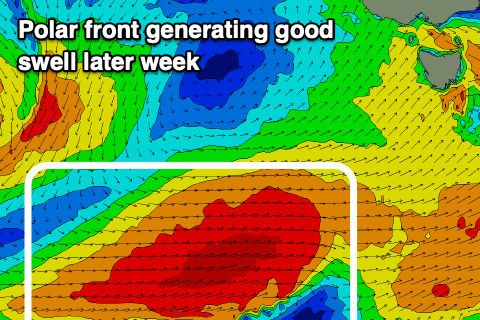
Good run of swell through this week
Southern Tasmania Surf Forecast by Craig Brokensha (issued Monday 26th August)
Best Days: Tuesday, Wednesday morning, Friday, Saturday
Recap
Small fun waves all weekend, biggest Sunday, while today a short-range swell has kicked the surf to 2-3ft.
Today’s Forecaster Notes are brought to you by Rip Curl
This week and weekend (Aug 27 – Sep 1)
The surf should drop back to a small 1-2ft tomorrow but into the afternoon our good new SW groundswell is due to fill in.
This will be followed by further pulses of groundswell, best Friday.
Over the last couple of days an east-southeast tracking frontal progression has been generating W/NW fetches in our south-western swell window, with an intensification yesterday afternoon seeing winds reach gale-force.
A moderate sized SW groundswell is expected of this activity, kicking tomorrow afternoon to 3ft across Clifton and easing form a similar size on Wednesday morning. Conditions will be clean most of tomorrow with a persistent W/NW tending NW offshore, good again Wednesday morning and out of the NW ahead of a SW change as a front moves through.
 The change will bring an additional increase in SW windswell through the afternoon but the models are combing this with the existing groundswell and over-forecasting the size a little.
Some new mid-period SW swell will be seen into Thursday to the 3ft range, ahead of a new S/SW groundswell later in the day and Friday morning produced by a trailing polar fetch of W/SW gales following Wednesday's front.
Winds on Thursday look a little suss and from the W/SW, possibly W'ly for a period and then varying Friday from the NW tending NE and then E/NE with the new S/SW groundswell to 3-4ft.
Come the weekend the surf will ease away from a small 2ft Saturday, tiny Sunday with favourable N'ly winds.
Longer term there's nothing too significant on the cards as the storm track pushes too north for us, but more on this Wednesday.

