Messy S/SE swell for the weekend, with a smaller S/SW swell next week
Southern Tasmania Surf Forecast by Craig Brokensha (issued Friday 9th August)
Best Days: Protected spots tomorrow AM, early Monday morning, Tuesday keen surfers, Wednesday morning
Recap
Clean and tiny easing S'ly swell yesterday, with the swell clean and tiny again this morning. An onshore change has since moved through as a deepening low forms to our south-east.
Today’s Forecaster Notes are brought to you by Rip Curl
This weekend and next week (Aug 10 - 16)
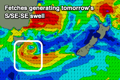
The dynamics around the intense low that's developed south-east of has changed a little again and it looks like we'll now seeing the most swell tomorrow.
Currently a fetch of strong to gale-force SE-S/SE winds are being projected up towards us, through our southern and south-eastern swell windows, with winds due to back off a little overnight.
 A spike in S/SE swell is due tomorrow morning, coming in around 3-5ft across Clifton, easing back through the day.
A weak fetch of S/SE winds will remain aimed into us Sunday keeping weaker and lower period levels of S/SE swell hitting the coast but mainly to the 3ft range.
Conditions will be poor across Clifton but OK for protected spots tomorrow with a gusty S/SW breeze easing later in the afternoon and then poor S/SE winds on Sunday.
Come Monday the S/SE swell looks to be on the way out and a weak front pushing up and into us through the day will generate a small S/SW swell for later in the day and more so Tuesday.
The size off this front isn't looking too flash now, with the vigorous polar system that was forecast to form south of us now due to form a little later and further east, just on the edge and then out of our swell window.
Instead we'll see a mix of S/SW and S'ly groundswells to 2-3ft across Clifton Tuesday. Dawn Monday should see a W/NW breeze before reverting back to the W/SW, onshore most of Tuesday unfortunately with a weaker W/SW wind.
Longer term there's a new inconsistent long-range W/SW groundswell due Friday, produced in our far swell window, south-west of WA on the weekend and early next week. At this stage we're looking at an inconsistent 1-2ft of swell, but more on this Monday. Have a great weekend!

