Windy S-S/SE swells ahead of a stronger S/SW groundswell
Southern Tasmania Surf Forecast by Craig Brokensha (issued Wednesday 7th August)
Best Days: Thursday morning, protected spots Sunday and Monday, Tuesday and Wednesday morning
Recap
The S/SE swell due yesterday was only reported at 2ft+, a bit under the expected 3-4ft, with tiny leftovers seen into this morning. A small and tight mid-latitude low moving under us during the day should have kicked up a pulse of W/SW swell to the 2ft range but with onshore winds.
Today’s Forecaster Notes are brought to you by Rip Curl
This week and next (Aug 8 - 11)
Any swell generated by the small low this afternoon will ease back tomorrow from 1-2ft max across Clifton. Conditions look great with a persistent N'ly breeze holding all day.
The dynamics surrounding the deepening low drifting south-east across us into the end of the week and weekend have changed, as has the strength of the polar front projecting up towards us early next week.
We're now looking at a weaker system moving across us with a late burst of strong S'ly winds into us Friday evening being followed by a broader and better fetch Saturday evening and Sunday.
A weak onshore 3ft of S'ly swell with W/SW winds is now due on Saturday, kicking more to 4-5ft on Sunday out of the S/SE with strong S/SE winds.
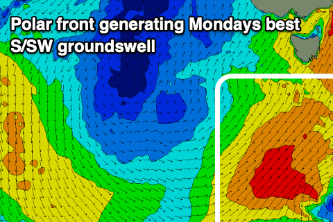
 We'll then see a strong polar front projecting a broad fetch of strong to gale-force S/SW winds up through our southern swell window on Sunday will generate a larger S/SW groundswell for Monday to 4-5ft+. Winds look to shift back to the W/SW-SW, favouring protected spots, back to the W/NW on Tuesday as the S/SW swell eases.
The surf will continue to ease into next week with favourable winds and there's nothing of significance due until the following weekend, therefore try and work the coming swells.


Comments
Why does your surf model forecast not match your notes Forecast
This discrepancy does occur quite often so which one should we take
The notes first and the model guidance as a guide.
This is a really dynamic system and keeps changing slightly with each update, resulting in a change in the size of the windswell and biggest days and varying model guidance.
On this, Monday's swell from the front is now gone, aghhh, with the polar front now forecast to form further east and not pushing north. It's been going back and forth but hopefully it slips back a little.
Tassie Devil dusts the snow fields shoots north & blows Gold Coast off the Map.
30 kn Ekka Winds arrive a week early to rise a rare 'westerly' one day spike.
Equally as rare the westerly swell spike from The Red Wave that wipes out NZ Alps.
Blink & yer miss it...Bummer! Should've been here a second ago!
Just a few days to scout around for a weep-hole in The Great GC Storm Bank.
Only takes a hot flush to fire up the weekend crew....tbb spoke too soon!
I liked it when you used the forecaster notes based on the other models which gave an idea of whether they were converging/diverging from the WAMS and swellnets model. Anyways hopefully this weekend delivers yew cheers craig
Yeah that's what I usually do, forgot to check with EC in this case though! Ughh.