Windy west swells inbound
Southern Tasmania Surf Forecast by Craig Brokensha (issued Friday 12th July)
Best Days: Dawn Sunday, limited options Monday, Tuesday afternoon onwards
Recap
Tiny waves yesterday, with a little sign of life today, kicking slightly to 1-1.5ft.
Today’s Forecaster Notes are brought to you by Rip Curl
This weekend and next week (Jul 13 - 19)
A better increase in W/SW swell is due tomorrow across our coasts, but the front linked to it will bring poor and gusty onshore W/SW tending SW winds.
 Junky waves building to 2-3ft are expected, but the quality will be low.
Early Sunday winds are now expected to be NW-W/NW around dawn with a mix of swells to 2ft, but swinging gusty W through the morning and then W/SW into the afternoon as our stronger polar low come front push up and into us.
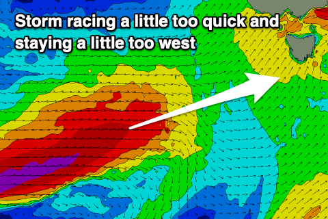
This low has formed south-west of WA and is generating a fetch of severe-gale to storm-force W'ly winds in our western swell window.
We'll see the low dipping east-southeast and then up and into us over the coming days, but the track and fast pace action of this transformation will see the storm outrunning the swell its producing.
Unfortunately we're now expected to see a smaller and more westerly swell event, which is a shame.
Sunday afternoon wave heights should start building from the front pushing across us, reaching 3-4ft by dark but with those gusty W/SW winds.
Monday will see the peak and we're looking at waves to 3-5ft across Clifton and out of the W/SW, likely tiny in protected spots. Winds will be generally out of the W/SW, but may tend W/NW for a period through the morning around Clifton.
Moving into Tuesday and Wednesday, reinforcing pulses of mid-period W/SW swell are due off a couple of weak trailing fronts moving in and under us next week.
Tuesday should come in around 3ft to maybe 4ft and conditions will improve as a morning W/SW breeze tends more W/NW into the afternoon.
Wednesday morning looks a bit cleaner as the swell drops back to 2-3ft, likely hovering around this size until the weekend. We'll have a closer look at this again on Monday though. Have a great weekend!

